Caption
The first significant heat wave of 2025 will arrive in Georgia starting the week of June 22. Heat index values in the triple digits are expected in many parts of the state midweek.
Credit: National Weather Service
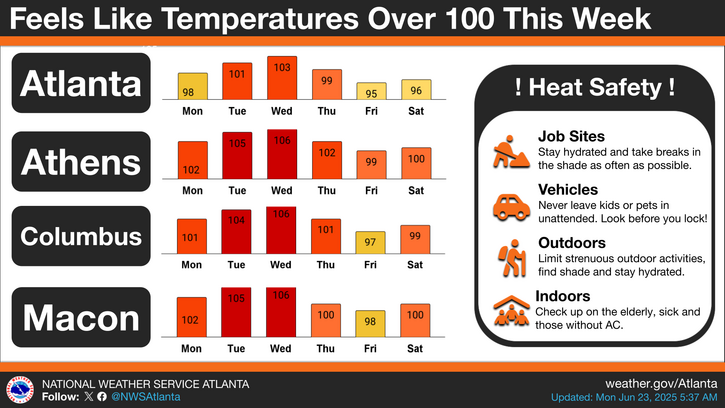
While the heat index could go above 100 degrees in many parts of Georgia, the National Weather Service has issued a Hazardous Weather Outlook for North and Central Georgia.
On Monday, the probability for widespread hazardous weather is low. Heat index values between 100 and 104 degrees are expected for portions of North and Central Georgia this afternoon and evening.
But Tuesday through Sunday, heat index values between 100 and 108 degrees are expected across portions of northern and Middle Georgia between Tuesday and Thursday, with the hottest conditions expected on Tuesday and Wednesday.
The heat may be hazardous, especially for vulnerable populations.
Scattered afternoon and evening thunderstorms should return Wednesday and linger through the weekend.
Not just regular summer hot, but an increasingly persistent type of excessive heat caused by a combination of climate change and specific weather conditions.
In addition to the dangerous heat indexes experienced across the country this summer, this week's triple-digit threat brings an extra element of dread and peril: a heat dome.
The National Oceanic and Atmospheric Administration investigated what triggers heat domes and found the main cause was a strong change (or gradient) in Pacific Ocean temperatures.
But you don't have to leave near a California beach to feel its effects. It can affect several continents.
Here's the way NOAA describes the phenomenon:
"Imagine a swimming pool when the heater is turned on — temperatures rise quickly in the areas surrounding the heater jets, while the rest of the pool takes longer to warm up. If one thinks of the Pacific as a very large pool, the western Pacific’s temperatures have risen over the past few decades as compared to the eastern Pacific, creating a strong temperature gradient, or pressure differences that drive wind, across the entire ocean in winter.
"In a process known as convection, the gradient causes more warm air, heated by the ocean surface, to rise over the western Pacific, and decreases convection over the central and eastern Pacific. As prevailing winds move the hot air east, the northern shifts of the jet stream trap the air and move it toward land, where it sinks, resulting in heat waves."
These heat waves trap warm air and humidity inside a dome-like bubble, driving temperatures on the ground sky-high.
The dome starting Tuesday and running through Saturday will affect most of Georgia. Heat advisories and excessive heat warnings will be in effect.
Check your local forecast by county here.
According to Climate Central's Climate Shift Index, climate change will make extreme heat conditions in Georgia this week at least four times more common than without climate change. The index or CSI is a categorical scale defined by the ratio of how common (or likely) a temperature is in today's altered climate vs. how common it would be in a climate without human-caused climate change.
Anyone overcome by heat should be moved to a cool and shaded location, especially before heatstroke occurs.
Heatstroke is a life-threatening emergency. Call 911.