Banner Image
Blog
Section Branding
Header Content
Scouts: Earn Your Weather Merit Badge!
Primary Content
During my free time, I am honored to volunteer as a Weather Merit Badge Counselor to the local Cub, Boy, and Girl Scouts. For the past few years, I have taught the Weather Merit Badge at various Boy Scout Jamborees, and I have guided Cub Scouts towards the completion of their Weather Pins. As part of the journey of earning the badge, the Scouts and I discuss the different types of severe weather in Georgia, and how the weather alerts reach the public. Below are examples of some of their requirements and the information they learn while fulfilling the activity.
Cub Scouts Weather Pin Requirement 4
4: Describe a potentially dangerous weather condition in your community. Discuss safety precautions and procedures for dealing with this condition.
Boy Scouts Weather Merit Badge Requirement 8B
8b: Visit a National Weather Service office or talk with a local radio or television weathercaster, private meteorologist, local agricultural extension service officer, or university meteorology instructor. Find out what type of weather is most dangerous or damaging to your community. Determine how severe weather and flood warnings reach the homes in your community.
Girl Scouts Legacy: Naturalist Sky Badge Step 2 Choice 3
Weather Watch: Try to speak with a meteorologist about how weather is predicted and how often forecasts are accurate. Note: The post Students Ask: How Do Meteorologists Predict The Weather directly addresses these questions.
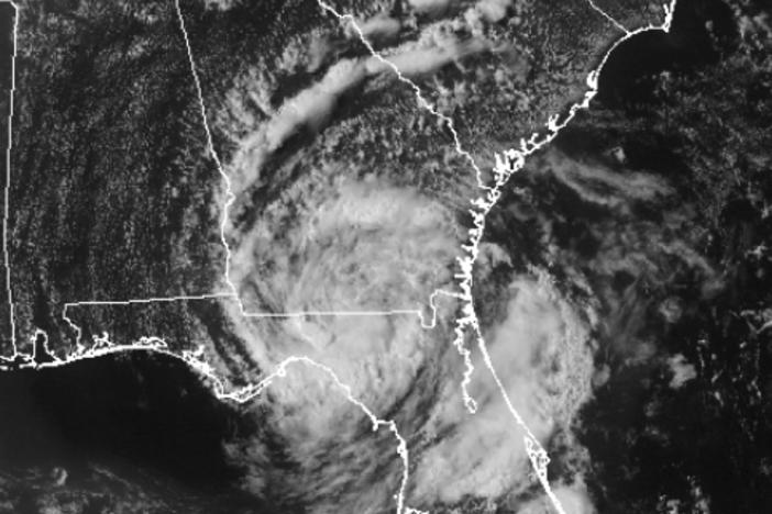
Nationwide, heat-related illnesses are the number one weather killers, followed by flooding and lightning. In Georgia, a myriad of weather-related hazards and disasters - including flooding, drought, lightning, thunderstorms, tornadoes, tropical cyclones, and winter storms - threaten citizens year-round. Statistically, thunderstorm hazards – including tornadoes, flooding, wind damage, and lightning – claim the most lives in Georgia and cause the most weather-related damage. In 2009, historic flooding occurred in several counties within north Georgia, causing over $250 million in damage and prompting 17 counties to receive Federal Disaster Declarations. Eight people lost their lives during Georgia's Epic Flood of 2009, many of which died when floodwaters swept their vehicles off of the road.
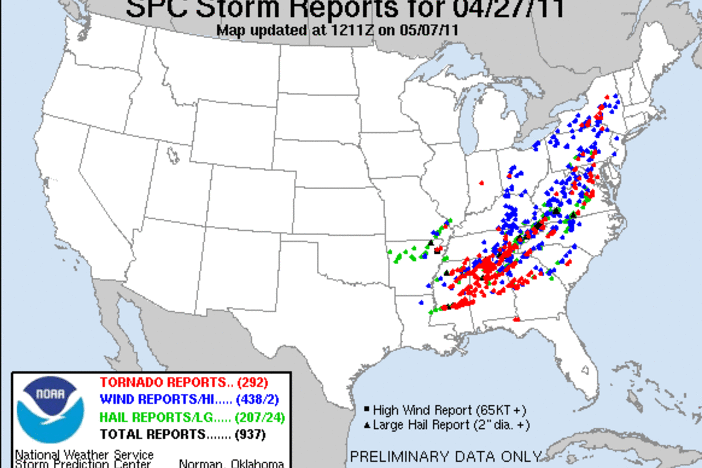
From April 25 - 27, 2011, nearly 350 people died during a tornado outbreak that raked through Alabama and Georgia (Source: NOAA National Climatic Data Center, State of the Climate: Tornadoes for April 2011). In Catoosa County alone, over $25 million in property damage occurred when an EF4 tornado destroyed the town of Ringgold, Georgia, killing 8 people and injuring 30 others (Source: NOAA National Climatic Data Center). Though super outbreaks like the April 25 – 27, 2011 event are rare events, Georgia still experiences weather conditions that support tornado development in each month of the year. (Bonus: Check out GPB Sports’ coverage of Ringgold’s Rebuild after the Catoosa tornado at the end of this post.)
Meteorologists use two different alerts, each describing a different sense of urgency, to warn the public of potential weather hazards. The first alert, or a “watch”, lets the public know that conditions are favorable for the weather hazard to occur (kind of like putting flour, eggs, butter, and sugar on the counter to make cookies - the conditions are right to make cookies, but there aren’t any cookies yet). During a “tornado watch,” meteorologists at the Storm Prediction Center are concerned that the weather conditions are favorable for tornadoes to develop within the time-span of the watch. During a weather watch, it is important to prepare for action: it is the time to add final touches to an emergency kit and to alert friends and family members of any necessary evacuation plans, such as going to the basement or storm shelter.
The second alert, or a “warning,” lets the public know that the weather hazard is imminent – it is either occurring, or it is about to occur at any moment. (In my cookie analogy from above, a “warning” would mean the cookies are out of the oven and they are ready for eating.) During a “tornado warning,” National Weather Service meteorologists have noticed radar signatures that indicate that a tornado is forming in the clouds, or they have received confirmation from public spotters that a tornado has indeed formed and is a danger to the public. During a weather warning, it is important to take action: grab the emergency kit and head to safety immediately. While both watches and warnings are important, warnings are more urgent, and require immediate action; watches are not as urgent, but do require continuous monitoring in case weather conditions deteriorate into the warning category. In each case, the National Weather Service sends out a message via the Emergency Alert System (EAS), which is then brought to the public through NOAA radio and from local broadcast stations.

This is my favorite Red Cross NOAA Weather Radio! Not only does it have a hand crank, it also has solar panels on it!
When NWS meteorologists are monitoring Doppler radar imagery for tornadoes, they are scanning the imagery for specific signatures that indicate the possible presence of a tornado. The first image is a base reflectivity image, which indicates how much energy is being returned to the radar (a primer on how radars work can be found here). Often, when a tornado is present on a base reflectivity image, a “hook echo” can be found in the image. The “hook echo” is the location of the tornado - it is produced by the radar’s radio waves bouncing off of the tornado’s funnel of debris and returning to the radar.

A supercell in Paulding, Polk, and Haralson counties. The hook echo extends from Haralson to Polk County. At the end of the hook is the tornado, though the entire cell is under a tornado warning as designated by the red warning box.
However, “hook echoes” are not always present on radar imagery, especially when the tornado is surrounded by areas of heavy rain (this situation happens very frequently in the southeastern United States). It is therefore important for meteorologists to look at a second image, the storm relative motion imagery, which shows the wind speed and direction for areas within the storm. On a storm relative motion image, meteorologists look for a “couplet”, or an area of wind moving away from the radar immediately next to an area of wind moving towards the radar. This “couplet” indicates that winds are moving in a circular motion, indicating the possible presence of a tornado.

The same supercell in Paulding, Polk, and Haralson counties. The couplet straddles the borders of Polk, Haralson, and Paulding Counties. At the center of the couplet is the tornado: the Doppler radar is indicating 70 knot winds moving towards the radar next to 40 knot winds moving away from the radar. The entire storm was moving towards the northeast, prompting a tornado warning box for areas upstream of the storm.
Once a “hook echo” or a “couplet” is spotted, meteorologists from the NWS issue a tornado warning for the area affected by the “hook echo” or “couplet”. The tornado warning then reaches the public through the EAS, NOAA radio, and from television and radio stations’ reporters and meteorologists.
So that’s it, Scouts! I hope that this helps you in your journey of earning your Weather Merit Badges and Pins! Feel free to leave a comment if you have any other questions about the weather. In the meantime, happy storm spotting!
~ Chrissy
GPB Sports Takes A Look At The Recovery Process of Ringgold, Georgia, After an EF4 Tornado Tore Through The Town
Filmmaker and Storm Chaser Sean Casey Gives A Tour Of His Tornado Intercept Vehicle!
Tour through the Hurricane Hunters' Airplane!
Additional Resources You May Like
Students Ask: How Do Meteorologists Predict the Weather
Students Ask: How Do Weather Radars Work
Information about the Atlanta Tornado from March 14, 2008
Information about the April 27 - 28, 2011 Tornado Outbreak
Information about the March 2, 2012 Haralson, Paulding and Cobb County Tornadoes
NWS Information about the Epic Floods of 2009
NWS Hot Seat Decision Simulator - Try Your Hand At Forecasting Severe Weather!
Dinosaur Train - Hurricane!
Dinosaur Train - Drought!
Secondary Content
Author
Bottom Content