Banner Image
Blog

Section Branding
Header Content
Students Ask - How Do Weather Radars Work?
Primary Content
Every year, I have the distinct joy of visiting the students of Ms. Jordan’s 6th Grade Science class as they study the unit of meteorology. Ms. Jordan is a teacher at South Central Middle School in Emerson, Georgia, which is located in Bartow County.
Ms. Jordan, her students, and I keep in touch through Ms. Jordan’s website and forum, and I wanted to share one of their questions – and answers – with you. Enjoy!
Dear Ms. Warrilow,
How can radars pick up storms and how do you predict the weather for a period of time?
- Nick
Hi Nick,
Thank you for your question!
The word “radar” is actually an acronym, which stands for RAdio Detection And Ranging (See? The big letters spell out RADAR).

Radome and tower in Amarillo, Texas
(Photo: NWS Weather Forecast Office in Amarillo, Texas)

Radar dish located inside the radome at the
Pueblo, Colorado NWS Weather Forecast Office
(Photo: NWS Weather Forecast Office in Pueblo, Colorado)
In the pictures above, a radome (the big golf ball-looking thing) houses a radar. A radar is a big machine that rotates in a circle, and as it’s rotating, it sends radio waves out into the atmosphere. The radio waves hit an object, like hail or rain drops, and the waves bounce back to the radar. A computer in the radar calculates the amount of waves that have returned and produces an image that corresponds to the amount of energy that returned to the radar. If there are no objects present to bounce back the radio waves, then the radar’s computer assumes that the weather is clear, and it produces an image that is free of precipitation.

Radio waves leave the radar.

Radio waves hit and bounce off of an object and return back to the radar.

The more objects that are present, the more radio waves return to the radar
(Source: WW2010 - Radar)
If there are a lot of objects present, then more radio waves will return to the radar, and the radar will generate an image with different colors on it. On a radar image, the brighter colors mean that more radio waves have returned to the radar – this tells meteorologists that there is more rain or hail present in the atmosphere.

Radar image showing the amount of reflectivity available during the Atlanta Tornado on March 14, 2008
(Source: NWS Weather Forecast Office in Peacthree City, Georgia)
Remember, though, that radars cannot “see” the difference between objects like hail, rain, and bugs – it’s only receiving reflected energy, not a “snap-shot” or a picture of the object that reflected the energy (this is the product of reflected light waves). Think of it like this – when someone knocks on a door, you know that a person is at the door (because they’re knocking!), but you don’t know exactly who is at the door (that is, until you open it and let them in!). Using this analogy, the hail, rain, bugs, and other atmospheric objects are the “people at the door” and the radio waves are the “knock” – you know something’s there, but you can only create an educated guess as to the object’s true identity. This process is called “remote sensing”.
(True story: I was volunteering at the National Weather Service one sunny afternoon, and we saw some objects show up on the radar, right around where Interstate 20 is located. We saw one green dot (which means the object is moving towards the radar), and one red dot (which means the object is moving away from the radar). Usually a red dot next to a green dot signifies a tornado, but that did not make sense since this was a beautiful, sunny day. My supervisor later explained to me that we were seeing large, semi-tractor trailer trucks whose movements were being picked up by the radar!)

Radar radio waves can move in both the
horizontal and vertical directions.
(Source: NWS Weather Forecast Office in Peachtree City, Georgia)
As of Fall 2011, the National Weather Service is in the process of updating the current radars to “dual-polarization” radars. Dual-polarization means that the radar sends out radio waves in both the horizontal and vertical orientations. The new “dual-pol” radars will be able to discern between heavy rain, hail, snow, and sleet. In addition, the detection of objects such as ground clutter, birds, and tornado debris will be improved. The National Weather Service and the National Severe Storms Laboratory have more information about the dual-polarization radars. The National Weather Service’s Warning Decision Training Branch also has special training scenarios for those who rely on radar data to make weather-related decisions – you can access those exercises here.

GOES Satellite in space (Source: NOAA, Lockheed Martin)
Meteorologists use satellites to observe clouds that may prove to be stormy well before they produce rain that is detected by the radar. A satellite is a machine that is launched into space in order to observe data on earth, including clouds, infrared energy, and rainfall amounts. Together, satellites and radars give meteorologists a balanced view of the current weather, including active thunderstorms, on Earth. Both NOAA and NASA have great websites that further explain how various satellites work – I also love the University of Illinois at Urbana-Champaign’s website, WeatherWorld2010. Beautiful current satellite imagery is also available at NOAA and NASA's GOES Project Science page.

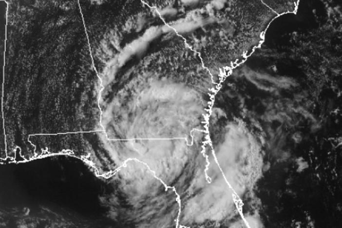
Visible satellite imagery from NOAA and NASA's GOES East Satellite
(Source: NASA and NOAA's GOES Project Science)
That was an excellent question, Nick, and I hope you enjoyed the answer! If you would like more information about radars and satellites, check out the following webpages:
WW2010: Radar
WW2010: Satellite
NWS in Peachtree City, Georgia, announces radar upgrade to dual-polarization
Happy storm spotting!
Every year, I have
Secondary Content
Author
Bottom Content