Caption
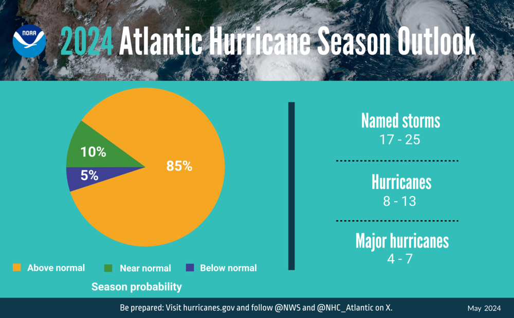
A summary infographic showing hurricane season probability and number of named storms from NOAA's 2024 Atlantic hurricane season outlook.
Credit: NOAA
LISTEN: an above-normal range of 8 to 13 hurricanes are expected to develop during the Atlantic hurricane season, which begins June 1. GPB's Benjamin Payne reports.

A summary infographic showing hurricane season probability and number of named storms from NOAA's 2024 Atlantic hurricane season outlook.
Federal forecasters' 2024 Atlantic hurricane season outlook is one for the record books: the National Oceanic and Atmospheric Administration announced Thursday that it is projecting more named tropical storms, hurricanes and major hurricanes than the agency ever has during its annual May outlook.
Between 17 and 25 named storms — of which roughly half are forecast to become hurricanes, including four to seven major hurricanes — are being forecasted by NOAA to occur between June and November, with a 70% confidence level cited by the agency.
NOAA chief scientist Rick Sprinrad was blunt in his remarks at a news conference, saying that the season “is looking to be an extraordinary one in a number of ways.”
That, he said, includes not just the number of storms, but also their intensity: the agency issued its second-highest-ever projection for its Accumulated Cyclone Energy (ACE) index, which measures overall wind energy across the entire hurricane season.
“In past years when we've seen high ACE numbers, those have historically been the years with the most destructive hurricanes,” Sprinrad said.

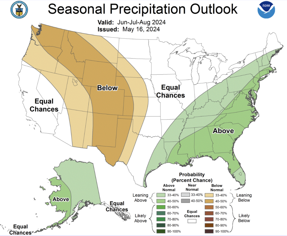
A NOAA chart shows Georgia leaning toward a 50-60% greater chance for above-average precipitation during the summer months of 2024.
Between 1980 and 2024, among its event categories, NOAA reported that Georgia experienced 64 severe storms,12 winter storms, four flooding events, 16 droughts, 24 tropical cyclones, three freeze events, and three wildfire billion-dollar disaster events (CPI-adjusted).
A major factor behind the powerful strength projected this year: La Niña, a climate pattern expected between August and October in which ocean temperatures rise over the Atlantic, effectively feeding energy to tropical storm systems.
Last month continued our planet’s feverish pace to the year, with April 2024 ranking as the warmest April on record. April was also the 11th month in a row of record-warmth for the world, according to scientists and data from NOAA’s National Centers for Environmental Information.
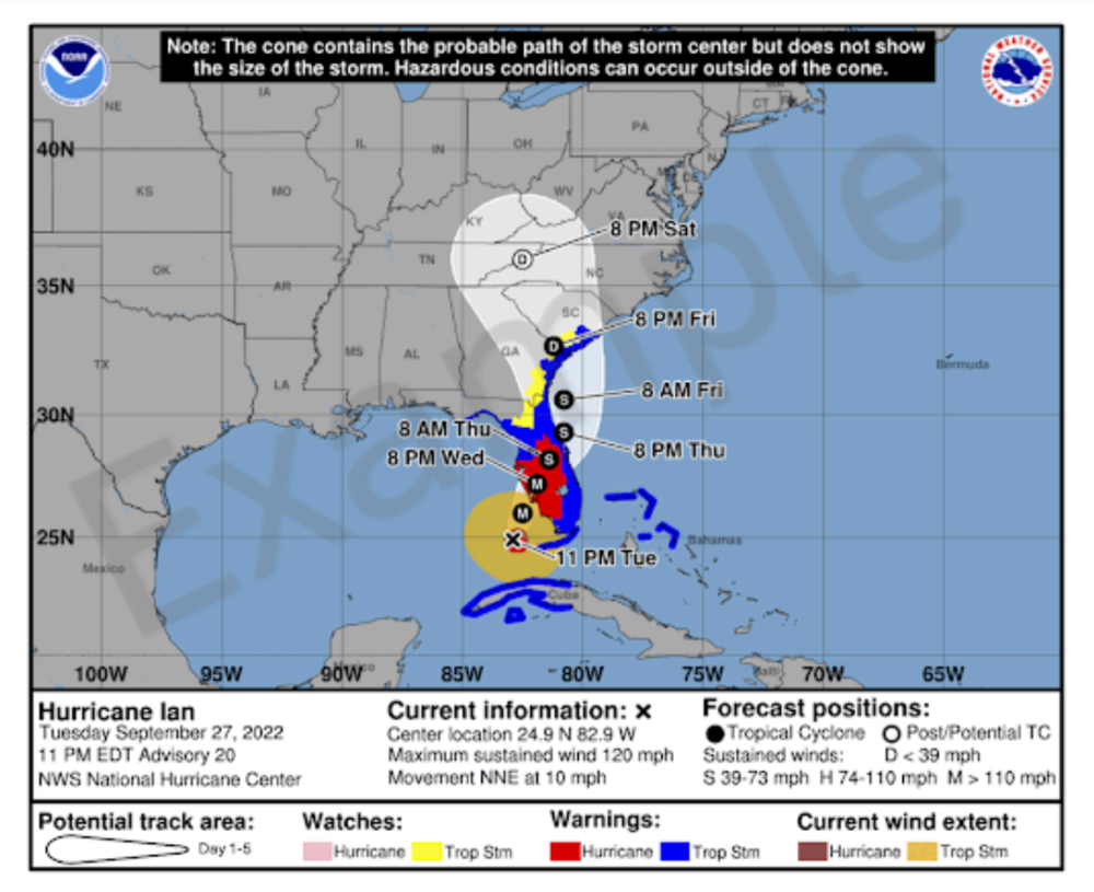
New to NOAA's hurricane preparedness tools this year is an enhanced forecast cone which shows not only the projected path of the storm's center, but also National Weather Service watches and warnings that extend well beyond.

An example graphic showing NOAA's newly enhanced cone forecast.
“This is a way that we can show everyone in the public and give everybody in the media a graphic to show, to say, ‘Wow, there's sure a lot of impacts outside that cone, right?’” said NWS director Ken Graham. “The graphic is so powerful because it means more than me saying, ‘Hey, there's impacts outside the cone’…Now, you can see it.”
Many parts of rural Georgia were battered last year by Idalia, which entered the state as a Category 2 hurricane on Aug. 30 in Valdosta near the middle of the Georgia-Florida border, killing one man and destroying dozens of homes.
Although the eye of Idalia steered clear of more densely populated areas along Georgia's coast — such as Savannah and Brunswick — it still dealt damaging winds there, with gusts nearing 70 mph along both St. Simons Sound and Tybee Sound.