Georgia Rocks! The Geology of Georgia
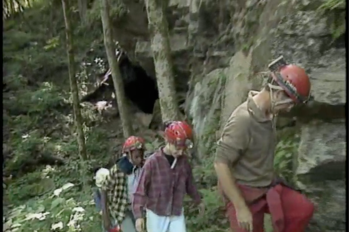
Allen Padgett from the Department of Natural Resources leads a group of students into a cave in Cloudland Canyon in the Appalachian Plateau of northwest Georgia. Along the way he describes how caves and valleys in north Georgia were formed by the forces of nature lifting up massive rocks to create mountains with pockets underneath.
Georgia Rocks! The Geology of Georgia
Allen Padgett from the Department of Natural Resources leads a group of students into a cave in Cloudland Canyon in the Appalachian Plateau of northwest Georgia. Along the way he describes how caves and valleys in north Georgia were formed by the forces of nature lifting up massive rocks to create mountains with pockets underneath.
Social Studies
Locate Georgia in relation to region, nation, continent, and hemispheres.
Distinguish among the five geographic regions of Georgia in terms of location, climate, agriculture, and economic contribution.
Locate key physical features of Georgia and explain their importance; include the Fall Line, Okefenokee Swamp, Appalachian Mountains, Chattahoochee and Savannah Rivers, and barrier islands.
Analyze the importance of water in Georgia's historical development and economic growth.
1. Illustrate a map that shows was Georgia looked like 100 million years ago.
2. How is North Georgia’s land different from the rest of the state and why?
3. Why does studying geology help us to understand our history in the state of Georgia?
1. Create a journal of the sights you might see if you were exploring a cave. Be sure to express feelings and how these sites might affect you. You may pretend you are looking for someone who is lost, or you might pretend you are a geologist who is exploring a cave for the first time.
2. Examine a physiographic map and describe Georgia’s diverse geography by pointing out key physical features including the Fall Line, Okefenokee Swamp, Appalachian Mountains, Chattahoochee and Savannah rivers, and the barrier islands. Use a state highway map to find Cloudland Canyon State Park where this adventure was filmed.
canyon: deep, narrow valley with steep sides
stalactite: a deposit that hangs from the roof of a cave in the shape of an icicle; formed by the dripping of calcium carbonate in the soil
stalagmite: upward-growing, massive calcite mounds deposited from drip water
1. Illustrate a map that shows what Georgia looked like 100 million years ago.
Maps should show that Georgia was partially covered with a great ocean. Because of volcanic and earthquake activity, the land changed. The water receded and mountains were formed in the northern part of the state.
2. How is North Georgia’s land different from the rest of the state and why?
The base of the soil in north Georgia is granite. It has had much earthquake activity so it has mountains. This part of the Appalachian chain is quite old; note that the tops of the mountains are rounded, as compared to the Rocky Mountains, which are relatively new.
3. Why does studying geology help us to understand our history in the state of Georgia?
The geology – the scientific study of the physical history of the earth – the rocks, and physical, chemical, and biological change that has and is taking place on the earth – of an area tells us how people lived over time. It tells us why the land is like it is. The northern part of Georgia was not under water, so it has a solid bedrock of granite as its foundation. The southern part was an ancient ocean and is covered mainly with sand. The vegetation as well as the topography of the land in each area is different. Growing seasons, weather, availability of water, and topography (hills, valleys, flatland, etc.) are all determined by geology. People live where there are animals to hunt, food to grow, and water to drink. Students should be able to trace where people might have been more likely to live in the early days of this place we call Georgia today.