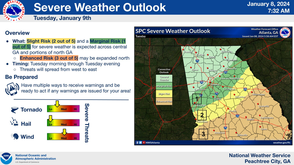
Caption
A map shows where severe weather is possible in Georgia the week of Jan. 8 to Jan. 14, 2024.
Credit: National Weather Service
LISTEN: GPB's Orlando Montoya speaks with National Weather Service meteorologist Vaughn Smith about this week's Hazardous Weather Outlook for the state of Georgia.
–––
The National Weather Service issued a Hazardous Weather Outlook is for Georgia through Sunday.
Light freezing rain will be possible in the higher elevations of far North Georgia late tonight, mainly at elevations above 2500 feet.
Beginning overnight into Tuesday through Sunday, storms are in the forecast, said NWS meteorologist Vaughn Smith.
"This system will have pretty much everything associated with it," he told GPB's Orlando Montoya this morning. "Now, the best place for tornadoes [Tuesday] will be across Central and South Georgia. but everywhere we'll see winds gusting 10 to 20, 30 to 40 and even 50 mph into the North Georgia mountains. So even though we're not expecting tornadoes in the North Georgia mountains, we'll have trees down because the winds will still be strong enough."
Showers and thunderstorms could sweep across the area during the day Tuesday. Some storms may be strong-to-severe, particularly south of a Columbus to Eatonton line. Severe thunderstorms that develop will be capable of producing damaging wind gusts and a few tornadoes.
Widespread non-thunderstorm wind gusts over 40 mph are also possible, with higher gusts across the northern mountains. Rainfall amounts of over 3 inches are possible in a swath from Columbus to Gainesville, with higher amounts across the northeastern mountains.
"We're also expecting hail with some of the stronger thunderstorms," Smith said. "It really is running the full gamut of everything, and we're expecting a little bit of snow [in certain elevations only] on the backside once it moves through on Tuesday. Tuesday night, some cooler air will be moving in and there'll still be a little bit of moisture left over. And we're not expecting much in the way of accumulation, but we will still see some... We could see it even all the way down to the Atlanta area, but it won't be any accumulation."
Another storm system is expected to bring showers and thunderstorms to the region Thursday night and Friday.
"It looks very similar to this one," Smith said. "So, we'll be paying very close attention to it ."