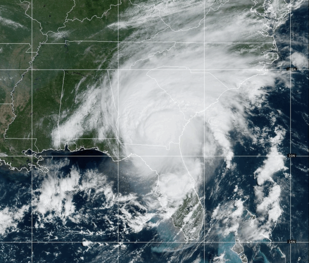
Caption
From space, Georgia's coast is pictured under a Hurricane Warning on Aug. 30, 2023, with tropical storm-force winds extending outward from the eye of the storm.
Credit: CIRA/NOAA
GPB News keeps Georgians informed about weather events that impact the state.
This blog will provide updates on Hurricane Idalia as it makes its way up the Florida coast and into Georgia, which may be affected on Wednesday, Aug. 30, 2023 and Thursday, Aug. 31, 2023. Idalia has the potential to bring tropical storm winds and flooding to South Georgia and Coastal Georgia.
Check this blog for updates about Idalia and its path through Georgia.
For the latest news on weather events and resources for preparation and safety, visit GPB.org/Storms.
For current watches and warnings from the National Weather Service click here.
For local emergency management information in Coastal Georgia, click on the county name: Chatham, Bryan, Liberty, McIntosh, Glynn, and Camden. For all other counties, visit GEMA.
Remember: Before the storm, make a plan. During the storm, be safe. After the storm, find support. If you lose power and are a Georgia Power customer, you can check this power outage map. With an EMC? Start here or here.
___
1. Some residents of Cook County may go without power for a week
Cook County EMA Director Johnny West told GPB's Sofi Gratas that the storm caused structural damage but no injuries have been reported in the county. Over 15,000 people are without power since yesterday afternoon.
"We've got about 15 houses that we know of this morning that have got trees on them. We lost one house to a house fire yesterday due to the storm… We’re just getting into the recovery phase now," West said.
Some residents may go without power for up to a week, West said. Many outside the cities of Adel and Lenox are also without running water, and West says the county is working with the state emergency management agency to get supplies.
Find a map to power outages on Georgia Power's website.
2. Savanah municipal services will fully reopen on Friday.
The City of Savannah will fully reopen services on Friday. Sanitation collection resumed today on a modified schedule, and city officials are working to clear debris.
___
The National Weather Service has downgraded Idalia to a Tropical Storm.
The Storm Surge Watch has been discontinued along the Georgia coast.
The Hurricane Warning along the coasts of Georgia and South Carolina has been changed to a Tropical Storm Warning.
The Hurricane Watches have been discontinued.
A Storm Surge Warning is in effect for St. Catherine's Sound, Georgia to South Santee River, South Carolina.
___
The City of Savannah has opened a safety center at the Savannah Cultural Arts Center at 201 Montgomery Street.
The temporary safety center will close at 8 a.m. on Thursday. Pets will not be allowed at the center.
Georgia's coast is still under a Hurricane Warning, with tropical storm-force winds extending outward from the eye of the storm. By late evening hours, most of the wind will have shifted northward to South Carolina as Idalia cruises up East Coast and out into the Atlantic Ocean toward Bermuda. Many counties in Georgia are under Flash Flood Warnings. Click here to see the list of counties and read our story about flooding, how to recognize different types of floods and how to stay safe during and after floods.
___
1. Idalia remains Category 1 hurricane as it tears across south Georgia
Idalia remains a Category 1 hurricane with winds of 85 mph (140 kph) as it crosses south Georgia, the National Hurricane Center said at midday Wednesday, The Associated Press reports.
The storm’s center is northeast of Valdosta, Georgia, and on a path toward the populous Savannah area.
Idalia’s fierce winds uprooted trees and sent rain flying sideways in Valdosta, near the Florida line. Video from news outlets showed a large tree toppled onto a house, an awning mangled and twisted outside a storefront, and standing water on some roads.
The White House says President Joe Biden will deliver remarks Wednesday afternoon about the federal response to Idalia.
2. Workers rush to tie down boats in Savannah, Georgia
On the Georgia coast, workers finished tying down roughly 20 sailboats and motor yachts docked at the Bull River Marina on Wilmington Island just east of Savannah, the Associated Press reports.
Brandon Long, a charter boat captain and the marina’s owner, planned to shut off the marina’s fuel lines and electricity before heading inland to ride out the storm.
Long said he worried most about the 3 to 5 feet of storm surge forecast to coincide Wednesday night with a higher-than-normal high tide amplified by a full moon.
“The surge is my biggest concern,” said Long, whose marina has more than 3,000 feet of floating dock. “If these docks float off their pylons or come apart because of the violent current and the choppy waters, then that’s what destroys a marina.”
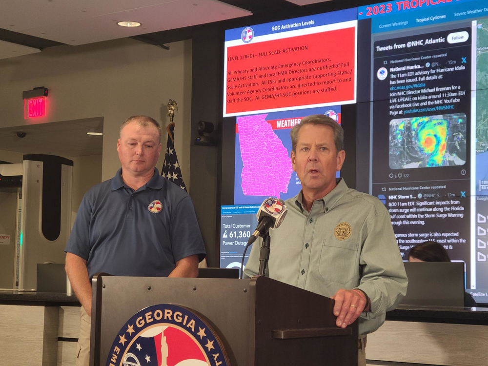
1. Governor Brian Kemp provided statewide updates.
Georgia Governor Brian Kemp held a press conference this morning at the Georgia Emergency Management Agency Headquarters to share updates on the state’s response to Hurricane Idalia.
Over 61,000 Georgians are without power after Hurricane Idalia made its way into South Georgia this morning. GEMA officials say the storm entered the state at Category 3 and has gone down to Category 1.
Governor Kemp says even as the storm weakens people still need to take precautions.
“It’s a dangerous storm. People need to prepare. They need to be ready when its coming through and either move a county or two up, if they have the ability to do that, If not make sure they’re in a secure location. Watch out for downed power lines," he said.
15 GEMA crews are standing by and will move into the affected areas once the storm passes or winds drop below 35 miles per hour.
2. McIntosh County prepares for high winds.
Wind speeds will exceed 40mph when Hurricane Idalia hits Coastal Georgia this afternoon.
Of the hurricanes to make landfall in Georgia, county EMA director Ty Poppel says Idalia will be the first since the late 1800s to bring sustained hurricane winds to coastal McIntosh County.
“We've had a lot of debris damage from Irma and Matthew … we've had some winds come through, but nothing hurricane sustained,” Poppell said from the county EMA center in Darien. “So we have prepared as best we can and we have advised everybody now to shelter in place.”
The county issued a voluntary evacuation for its barrier islands on Tuesday. Poppell said the county already received assistance with an emergency evacuation off Sapelo Island Wednesday morning.
3. Savannah braces for Idalia's Impact.
Savannah, Georgia — the state's oldest city and the largest along its Atlantic coast — is bracing for Idalia as the tropical system works its way northeast toward the area.
Mayor Van Johnson warned the city's roughly 150,000 residents to not be complacent, even as Idalia is forecast to weaken to a category one hurricane by the time its center is forecast to arrive Wednesday evening.
"We have to take this seriously," he said at a press conference. "The key here is don't be out on the streets if you don't have to be out on the streets. Stay home, sit down somewhere and just ride this thing out."
A popular tourist destination, Savannah saw certain visitor activities — including trolley and walking tours through the city's verdant, cobblestoned downtown — suspended as of noon until further notice.
Dennis Jones, who leads emergency management for Savannah's Chatham County — the state's largest county outside metro Atlanta — urged its roughly 300,000 residents to shelter in place amid the risk of flooding from storm surge and high tides.
"We've been preparing for this storm since Saturday," Jones said. "The threat is real. We can expect the conditions to continue to deteriorate throughout the day."
Mayor Johnson appeared dismayed by recent conversations he had had with Savannah residents who he felt did not understand the gravity of the situation.
"From folks that I've communicated with, they don't seem to think it's serious. You know, 'It's not coming from the Atlantic; it's coming from from behind us, our back door, so to speak.' And so, for some reason, they don't equate that as being just as dangerous. I think it brings on some different challenges for us, but it is still severe and hence why we're taking it just as serious as if it were coming through the front door," Johnson said.
4. Thomasville Officials set curfew for Wednesday evening.
Officials in Thomasville, Georgia have set a curfew for 9 p.m. in Thomasville and Thomas County. Rain and wind is expected to worsen at 8 p.m., officials said.
___
1. Moultrie experiences high wind speeds:
Colquitt County Emergency Management Director Justin Cox reports Moultrie is experiencing 36 to 38 MPH wind gusts and 16 MPH sustained winds.
Moultrie is seeing trees fall with heavy rain and winds.
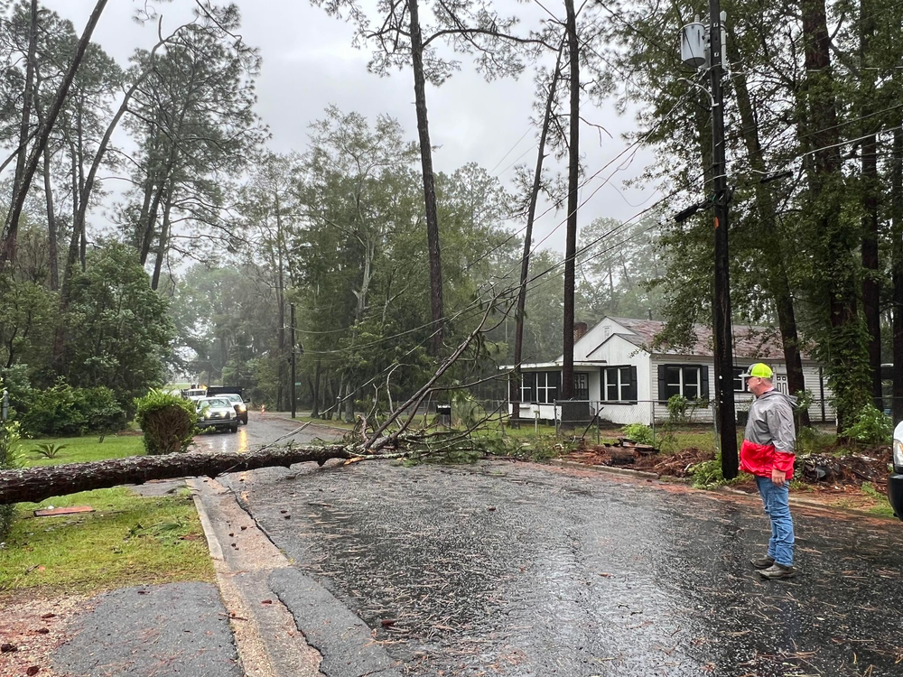
Public Works and Utility crews are working to restore power near the intersection of 4th Avenue SW and 6th Street SW after a pine tree fell on a power line across 6th Street SW. Crews are actively working to clear this roadway.
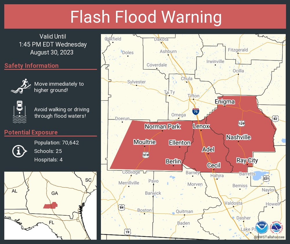
2. Flash Flood warning issued for parts of South Georgia.
The National Weather Service issued a flash flood warning until 1:45 p.m. Wednesday for Berrien, Colquitt and Cook Counties in south central Georgia.
3. Savannah will feel Hurricane Idalia strongest between 5 p.m. and 10 p.m. on Wednesday.
Savannah City Manager Jay Melder warned of power outages in that time frame.
The Ware County emergency management agency based in Waycross Georgia is telling people to shelter in place.
Hurricane force winds are expected to roll in between 11 a.m. and last through the afternoon.
The National Weather Service also has the county under flood and tornado watch as of Wednesday morning.
EMA Director for Ware County Jonathan Daniels said three safety shelters are open and ready for anyone who needs them.
"If they live in substandard housing or a mobile home or something, they don't feel comfortable. They can go into one of these shelters right now," he said.
Shelters aren’t open overnight, but Daniels said plans may shift depending on storm damage.
National Weather Service meteorologist Ben Nelson warns of hurricane-force winds, not only along coast but inland across Southeast Georgia:
___
1. BRIDGE CLOSURES:
Georgia DOT is closing several bridges in the southeast coastal region ahead of Hurricane Idalia's anticipated gale-force winds. Please be advised that the times of the bridge closures are subject to change based on evolving weather conditions.
The cable-stayed bridge on State Route (SR) 25 that spans the Brunswick River in Brunswick-Glynn County will close at 10:00 a.m. Wednesday, August 30 to vehicular traffic.
US 17/SR 404 Spur cable-stayed bridge that spans the Savannah River in Savannah-Chatham County will close to vehicular traffic at 2:00 p.m., Wednesday, August 30.
Also closing to maritime traffic only at noon on Wednesday is the Houlihan bridge on SR 25 spans the Savannah River in Port Wentworth. The bridge will remain open to vehicular traffic.
The closures will remain in place until further notice. Once the hurricane and its storm impacts subside, an extensive inspection of the bridges will be performed. Following inspection and clearance to reopen to traffic, Georgia DOT will issue an update.
2. In the Georgia city of Valdosta, now apparently directly in the eye of the Idalia, residents have been told to shelter in place until the storm passes:
A Shelter is open in Lowndes County from 6 a.m. to 7 p.m. Lowndes County Emergency Management is working with Park Avenue Church to provide a safe location for those individuals living in mobile homes or substandard housing who need a location to provide shelter during the storm. This will not be a long-term shelter, and little to no amenities will be provided. This is simply a safe location to seek shelter from the storm.
The shelter will be open on Wednesday, August 30, 2023, beginning at 6 a.m. and will close no later than 7 p.m. or when the tropical storm force winds have moved out of Lowndes County.
Individuals coming to the shelter should park in parking lot B, which is on the corner of Park Avenue and Slater Street. The shelter entrance will be through the double doors facing Slater Street.
Pets are allowed but must stay in a kennel while inside and be on a leash while outside. Kennels are not provided and are the pet owner's responsibility.
Please note that the Storm Shelter is for LOWNDES COUNTY RESIDENTS ONLY. There is not an overnight shelter in the area so those leaving other communities need to continue going north or find a hotel room if possible. The closest overnight shelters at the moment are in Macon and Cordele.
___
1. EVACUATION ORDER for Cumberland Island and Little Cumberland Island:
Chairman Ben Casey signed a State of Emergency for Camden County. Additionally, an evacuation has been ordered for Zone A, which consists of Cumberland Island and Little Cumberland Island.
Earlier this year the Camden County Board of Commissioners approved new hurricane evacuation zones for Camden County. The county now features four zones to better reflect risk and evacuation management. Camden County residents, regardless of zone, should strongly consider voluntary evacuation in low lying areas. Locations that have flooded in the past are likely to flood during this tropical event. Residents in manufactured housing should consider relocating to a stronger structure. Read more
2. Chatham County EMA issues State of Emergency with Hurricane Warning and Storm Surge Warning.
Hurricane force winds are possible this evening, with gusts up to 90mph.
The National Weather Service has issued a Hurricane Warning for Coastal Bryan, Coastal Liberty, Coastal McIntosh, Evans, Inland Bryan, Inland Chatham, Inland Jasper, Inland Liberty, Inland McIntosh, Long, and Tattnall counties
GPB's All Things Considered host, Peter Biello, talked with CNN Senior Meteorologist, Brandon Miller, about Hurricane Idalia.
___
Savannah City Manager Jay Melder says city crews will be strategically placed to ensure that tide gates and pumps are operational amid #Idalia, forecast to pass through Savannah as a tropical storm late Wednesday. He says park and tree crews will also be deployed to clear debris.
National Weather Service latest guidance:
Savannah Mayor Van Johnson issues evening curfew for Wednesday in the city of Savannah:
___
Tybee Island preparedness statement and road closures update
CEMA (Chatham Emergency Management) has entered the Readiness Phase and is closely monitoring Hurricane Idalia. A northward motion is expected, followed by a faster north-northeast motion later today and Wednesday. The center of Idalia is forecast to move over the eastern Gulf of Mexico today. Our area continues to be under a Tropical Storm Watch and Storm Surge Watch.
Timing: The greatest impacts are expected to occur in Chatham County Wednesday through Thursday. In the next 24 hours, Chatham County could receive Tropical Storm force winds.
Impacts: The greatest impact to Chatham County could be heavy rainfall, with predictions of up to 3-6 inches, coastal flooding, 2-4 feet of storm surge, rip currents, and Tropical Storm winds. Residents in low-lying areas should stay alert for possible flooding. A risk of severe weather, including tornadoes spawned by Idalia also exists. Tybee is expected to see the most impact on Wednesday 8PM - Thursday 8AM. There is the potential for Tybee to be without power for 48-72 hours.
––––
Gov. Kemp Issues State of Emergency In Preparation for Hurricane Idalia
Atlanta, GA – Governor Brian P. Kemp today issued a State of Emergency order for all of Georgia in preparation for Hurricane Idalia's anticipated impact later this week. Currently, the storm system is expected to move through the state Wednesday, bringing heavy rainfall and damaging winds throughout Southeast Georgia. The State of Emergency went into effect upon the governor's signature today, August 29, and will expire at 11:59pm on Friday, Sept. 8, 2023. You can read the Executive Order here.
"We are taking every precaution ahead of Hurricane Idalia's landfall tomorrow, and I am taking this additional executive action to ensure state assets are ready to respond" said Governor Brian Kemp. "Georgians in the expected impact area can and should take necessary steps to ensure their safety and that of their families. We are well positioned to respond to whatever Idalia may bring."
––––
NWS and NOAA Hurricane Center update:
___
Savannah/Chatham County's public transportation system is suspending operations on Wednesday, Aug. 30, 2023.
___
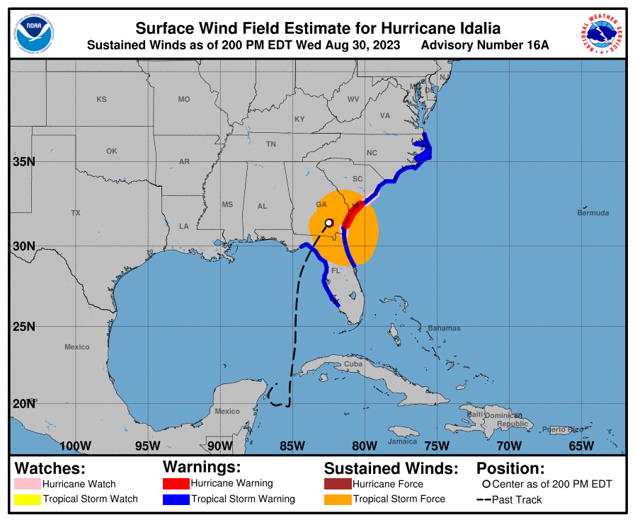
The National Weather Service predicts possible tropical storm conditions for Wednesday along the Georgia coast.
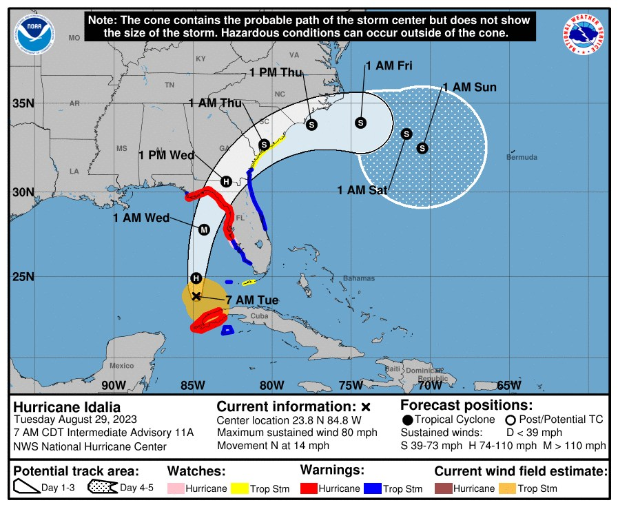
This graphic shows an approximate representation of coastal areas under a hurricane warning (red), hurricane watch (pink), tropical storm warning (blue) and tropical storm watch (yellow). The orange circle indicates the current position of the center of the tropical cyclone.
NHC tropical cyclone forecast tracks can be in error. Historical data indicate that the entire 5-day path of the center of the tropical cyclone will remain within the cone about 60-70% of the time.
___
The Savannah-Chatham County Public School System to close in-person learning this week, will shift to virtual learning until Tuesday, Sept. 5, 2023
From the Savannah-Chatham County Public School System:
"The track of Hurricane Idalia is expected to bring severe weather to our area with the greatest impact to Chatham County expected Wednesday through Thursday. As a precaution, Savannah-Chatham County Public Schools will close in-person learning and will shift to virtual learning on Wednesday, August 30, 2023, and Thursday, August 31, 2023. As a reminder, Friday, September 1, 2023, was already a scheduled E-Learning day in advance of the Labor Day holiday weekend. After the storm passes, SCCPSS Maintenance crews will assess any damage to our schools and school grounds. We expect schools to re-open on Tuesday, September 5, 2023, following the Labor Day holiday."