Section Branding
Header Content
GPB News updates on Hurricane Ian
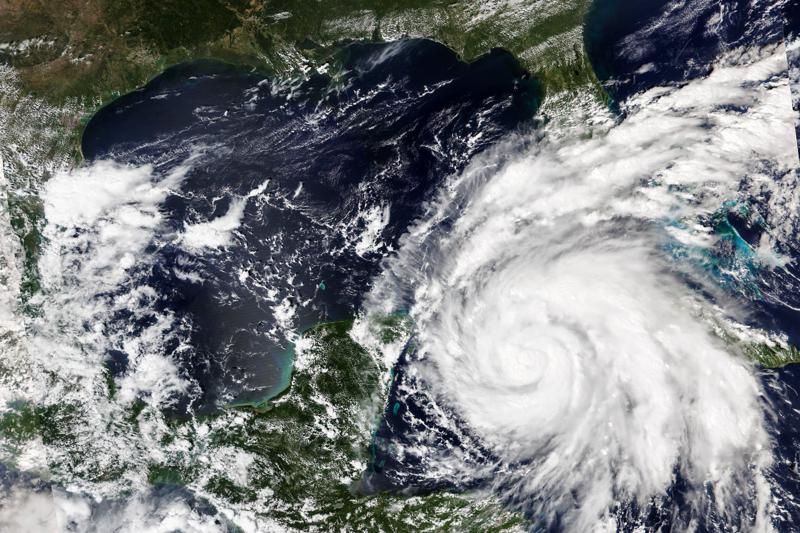
Hero Image
Primary Content
Visit GPB.org/storms for updates, safety resources, and emergency management information.
Visit the National Weather Service, Charleston, S.C. for Coastal Georgia weather forecasts and storm surge.
Visit the National Weather Service, Peachtree City, Ga. for weather forecasts for other regions of Georgia.
Here, you will find Georgia Emergency Management and Homeland Security Agency information.
Friday, Sept. 30, 2022: 4:22 p.m.:
PLEASE NOTE: This will be our final update for this article. For all future weather-related news, visit GPB.org/storms.
—
Friday, Sept. 30, 2022: 1:38 p.m.:
—
Friday, Sept. 30, 2022, 12:35 p.m.:
Friday, Sept. 30, 2022, 8:29 a.m.:
National Weather Service forecast for Savannah, Ga. Friday, Sept. 30, 2022:
- Storm Surge Warning
- Hazardous Weather Outlook
- Hurricane Local Statement
- Tropical Storm Warning
- Flood Watch until October 1, 12:00 AM EDT
__
Friday, Sept. 30, 2022, 7:49 a.m.:
Hurricane Ian is moving through the Atlantic Ocean, headed towards the South Carolina Coast.
Rebecca Shaw is a meteorologist with the National Weather Service, Charleston office. She says since the track of the storm has shifted further north, coastal Georgia will not see the worst conditions.
But she says there are gusty winds and there is a storm surge warning in effect.
She also warns of other potential hazards:
"There's going to be high surf, so just be careful at the beaches. We have a high risk of rip currents, too. There's lots of coastal hazards going on that just.... As it seems like its away from the area, there are impacts far from the center of the storm."
Shaw says conditions in coastal Georgia will improve throughout the day, but some could linger.
And Manny Toro, the Federal Emergency Management Agency's Region 4 response director, told GPB yesterday afternoon the agency has been working with local and state partners to be prepared for whatever Ian brings:
"I'm confident that we are monitoring effectively and postured to be able to support any of the communities that may be affected"
–GPB News, Devon Zwald reporting
__
Thursday, Sept. 29, 2022, 11:11 p.m.:
___
Thursday, Sept. 29, 2022, 4:43 p.m.:
Updates from around the state:
- In shipping news, the Georgia Ports Authority said it would continue operations at the Port of Savannah through 6-P-M Thursday.
Meanwhile, boats up and down the Ga. coast were being tied down to secure them to docks.
Shrimper Wyn Gale is on the waterfront in Darien.
"Yes sir, everybody's tied up, everybody's tied down, everybody's doubled their lines and let all their nets down off the rigging and stuff to keep the wind from blowing the boats over too bad."
- Georgia gas prices have risen slightly as Hurricane Ian crosses Florida and heads toward Georgia and South Carolina.
Triple-A says the average price for a gallon of unleaded gas today is three-dollars, 17-cents statewide, eight-cents higher in Metro Atlanta.
That's about two-to-five cents higher than last week.
The motor group's Montrae Waiters says, until Ian, gas prices nationwide had been trending lower.
"We think that once the storm passes and again as long as crude oil prices don't increase that hopefully gas prices will start to trend downward again."
Motorists are encouraged to report suspected illegal price gouging to the Georgia Consumer Protection Division.
- Flooding may be an issue in some parts of Coastal Georgia. Streets in some low-lying areas up and down the coast were inundated.
Bert Guy co-owns a hotel and restaurant on the waterfront in downtown Saint-Mary's near the border with Florida.
"They had to close the downtown St. Marys roads because the water crested out of the St. Marys River and then came up and it flooded the business across the street, Market on the Square. It got within six inches of entering my restaurant."
That was at this morning's high tide. And forecasts call for tonight's high tide to be a foot higher.
–GPB News, Orlando Montoya reporting
__
Thursday, Sept. 29, 2022, 12:30 p.m.:
Gov. Brian Kemp spoke Thursday morning near the Savannah International Airport, expressing relief that Hurricane Ian's center — currently in the Atlantic Ocean near Florida's Cape Canaveral — has seen its projected path shift further east away from Georgia, according to the National Hurricane Center.
"Thankfully, we've been very lucky overnight that the storm continues to move out to sea and further eastward," Kemp said. "But the coast is still going to be affected. Thank goodness it doesn't look like it's going to be as much as what we thought the path was going to be earlier in the week. So, we are blessed by that, but certainly praying for our friends in Florida."
Georgia Emergency Management Agency Director James Stallings also spoke, cautioning that although Georgia may be spared the brunt of Ian relative to South Carolina, residents should not underestimate the life-threatening danger posed by likely storm surge and flooding in coastal communities.
"If you're in a low-lying area that is prone to flooding, you should probably start taking precautions over those areas," Stallings said. "I don't think we're going to be looking at any mass flooding outside of areas that traditionally flood. The other concern that we've got at this time is the coastal push. So there's going to be some high tide and coastal flooding combined together. So, with that, we could see some beach erosion and things of that nature."
A state of emergency that was ordered by Kemp earlier this week went into effect 7 a.m. Thursday.
"That's continuing to make state resources available to local governments and entities within the hurricane's impact area," Kemp said. "The state operation center is at level one, which is full-scale activation. Teams from every relevant state agency are standing by to deploy to any potential affected counties when and if appropriate."
— GPB's Benjamin Payne in Savannah
—
Thursday, Sept. 29, 2022, 11:15 a.m.:
Gov. Kemp, Emergency Management Officials Provide Update on Tropical Storm Ian Preparations
Gov. Brian Kemp joined state and local emergency management officials, local leaders, and others in Savannah this morning at 9:15 a.m. to provide an update on Tropical Storm Ian preparations and the state's planned response. The State of Emergency issued by Governor Kemp on Tuesday went into effect this morning at 7 a.m. for all 159 of Georgia's counties, making state resources available to local governments and entities within the hurricane impact area. The Georgia Emergency Management and Homeland Security Agency (GEMA/HS) State Operations Center is now at a Level 1 full-scale activation and continues to monitor Tropical Storm Ian's progress. Teams from the relevant state agencies are also standing by to deploy to affected counties, when appropriate. The governor and emergency management officials are also coordinating with Georgia's utility providers, who have been staging equipment, inspecting the right-of-way paths of power lines, and preparing to respond to any power outages homes and businesses may experience.
At this time, the Savannah Airport remains open and operational. The Savannah port terminal cleared any waiting vessels last night and operations will continue until 6 p.m. this evening. All vessels have also departed the Brunswick port terminal and pilot operations have ceased until the storm passes. The Georgia Ports Authority will reassess needs and an expected timeline for return to operations on Friday. The Georgia Department of Transportation closed the Sidney Lanier Bridge in Brunswick at 9 a.m. today, and Houlihan Bridge is closed to boat traffic only. Please visit www.dot.ga.gov for more information.
_
Thursday, Sept. 29, 2022, 10:57 a.m.:
Here is the latest National Weather Service forecast for Savannah, Ga.:
Thursday (TODAY)
A 40 percent chance of showers, mainly after 1pm. Cloudy, with a high near 69. Breezy, with a northeast wind around 23 mph, with gusts as high as 34 mph.
Thursday Night
Tropical storm conditions possible. Showers, mainly after 9pm. Low around 62. Chance of precipitation is 80%. New precipitation amounts between 1 and 2 inches possible.
Friday
Tropical storm conditions possible. Showers, with thunderstorms also possible after 11am. Some of the storms could produce heavy rainfall. High near 73. Chance of precipitation is 90%. New rainfall amounts between 2 and 3 inches possible.
Friday Night
Showers likely, mainly before 8pm. The rain could be heavy at times. Mostly cloudy, with a low around 61. West wind 9 to 18 mph, with gusts as high as 30 mph. Chance of precipitation is 60%. New precipitation amounts between a quarter and half of an inch possible.
Saturday
A 20 percent chance of showers. Mostly sunny, with a high near 79. Southwest wind 8 to 10 mph.
Saturday Night
Mostly clear, with a low around 61.
Sunday
Sunny, with a high near 78.
__
Thursday, Sept. 29, 2022, 9:45 a.m.:
Associated Press: Hurricane Ian carved a path of destruction across Florida, trapping people in flooded homes, cutting off the only bridge to a barrier island, damaging a hospital from above and below and knocking out power to 2.5 million people as it dumped rain over a huge area on Thursday.
One of the strongest hurricanes to ever hit the United States threatened catastrophic flooding around the state. Ian's tropical-storm-force winds extended outward up to 415 miles (665 km), drenching much of Florida and the southeastern Atlantic coast.
Authorities confirmed at least one storm death in Florida — a 72-year-old man in Deltona who fell into a canal while using a hose to drain his pool in the heavy rain, the Volusia County Sheriff's Office said.
Life-threatening storm surges and hurricane conditions were possible on Thursday and Friday along the coasts of northeast Florida, Georgia, and South Carolina, where Ian was expected to move inland, dumping more rain well in from the coast, the hurricane center said.
The governors of South Carolina, North Carolina, Georgia and Virginia all preemptively declared states of emergency.
__
Thursday, Sept. 29, 2022, 7:45 a.m.:
__
Thursday, Sept. 29, 2022, 6:50 a.m.:
Clayton County Public Schools (CCPS) will pivot to remote operations on Friday, September 30, 2022, in anticipation of forecasted hazardous weather as a result of Hurricane Ian.
__
Thursday, Sept. 29, 2022, 5:40 a.m.:
From Morning Edition on GPB Radio:
Brian Haines is the meteorologist-in-charge at the National Weather Service, Charleston office.
He says for the Savannah area, storm surge is going to be the primary concern.
And, he says, this morning they're already seeing some impacts from Ian, including 40 miles per hour winds and high tides.
“The high tides are already going to start to become elevated. We don't want people to forget about this morning's high tide. So already we're running two feet above normal.
Haines also says he doesn't want people, especially in Savannah and Charleston, to focus on the exact track of the storm.
“Any slight nudge or change or wobble in the storm, that's going to be very hard to predict. So we want everyone to prepare as if the storm is coming for you, right. That's well within our uncertainty range. And if you live near the coast, take the storm surge seriously. If you're in a low lying area that's susceptible to surge, take the storm seriously.”
– Devon Zwald, GPB News
__
Wednesday, Sept. 28, 2022, 5:00 p.m.:
Update from the National Hurricane Center:
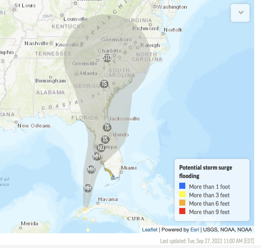
As Hurricane Ian moves through Florida, forecasters project it could travel east into the Atlantic Ocean, before turning toward Coastal Georgia or South Carolina.
National Hurricane Center acting director Jamie Rhome said that if Ian veers into the Atlantic, the ocean could whip up Ian's strength, intensifying storm surge in these low-lying areas.
"There's a reason it's called the Lowcountry," Rhome said. "It's flat and there's not much elevation there. So even a little bit of storm surge in these areas could be life-threatening."
Rhome warned that it's not just Ian itself that poses a threat, but also its aftermath in the coming weekend.
"We lose so many people after a storm because they get out and wander about," Rhome said. "They drive into flooded roads [and] power lines might be down."
Gov. Brian Kemp plans to speak Thursday morning at the Savannah International Airport about the state's preparation and response efforts.
- GPB's Benjamin Payne in Savannah
__
Wednesday, Sept. 28, 2022, 3:40 p.m.:
From NPR:
Hurricane Ian made landfall in southwest Florida's Lee County on Wednesday afternoon. The category 4 hurricane produced winds of 150 miles per hour and storm surge over 7 feet high in Naples before coming ashore.
The National Hurricane Center predicts Ian's high winds and rain will cause intense storm surge and flooding, resulting in catastrophic damage to homes and businesses. Storm surge in Lee and Charlotte counties could reach heights of 18 feet.
The National Hurricane Center's Acting Director Jamie Rhome said in an advisory that the time for evacuation has long passed. Those who remain in the storm's path need to hunker down in the center of their home and prepare for sustained devastating winds.
The hurricane's eyewall reached Sanibel and Captiva islands, west of Fort Myers, shortly after noon. A webcam on Fort Meyers Beach showed palm trees bending in the wind as waves toss furniture around in the surf.
Ian is forecast to continue making its way northeast across Florida. The situation on the ground will likely get worse before it gets better, as high tide isn't until 7:06 p.m. Wednesday, which will contribute to storm surge conditions.
The storm is expected to weaken after landfall, but could be near hurricane strength as it makes its way over Florida's east coast on Thursday, the NHC said. Ian will continue north toward Northeastern Florida, Georgia and South Carolina on Friday.
Updates about the storm can be found at the National Hurricane Center's website here.
__
Wednesday, Sept. 28, 2022, 3:00 p.m.:
From Savannah-Chatham County Public School System:
Due to the approach of the storm and the anticipated detrimental effects across the county, the Savannah-Chatham County Public School System has made the decision to shift to virtual learning on Thursday and Friday.
__
Wednesday, Sept. 28, 2022, 2:15 p.m.:
Georgia Power update:
Georgia Power is preparing resources to support customers living near the coast who may be affected by Hurricane Ian as the storm progresses.
Georgia Power is part of a nationwide mutual assistance network of utility providers who work with each other during emergencies. As Hurricane Ian moves inland, the power company will use their resources for parts of Georgia that may be affected before offering to assist nearby states like Florida.
John Kraft is with Georgia Power he says right now they’re getting help from the Midwest.
“We need so many bucket trucks, we need so many linemen, engineers and other teams. And then they'll send they'll send what they can spare. And it really helps to get the power restored in these major storms situations much faster than any company could do by themselves.”
Kraft says they’re continuing to monitor Hurricane Ian but teams won’t go out until they identify which areas are the most impacted.
– GPB News, Amanda Andrews
___
Wednesday, Sept. 28, 2022, 1:00 p.m.:
An update from the National Hurricane Center includes updated forecast for Georgia:
Wednesday, Sept. 28, 2022, 12:00 p.m.:
Due to the threat of inclement weather and out of an abundance of caution, a decision has been made to close all Lowndes County Schools and system offices on Thursday, September 29th, and Friday, September 30th.
__
Wednesday, Sept. 28, 2022, 11:45 a.m.:
___
Wednesday, Sept. 28, 2022, 11 a.m.:
TRAVEL UPDATE:
Georgia Department of Transportation: To help ease potential congestion along evacuation routes, beginning Wednesday, September 28 Georgia DOT is halting all projects requiring lane closures along Interstates 16, 75 and 95 south of Atlanta, and all maintenance and utility projects. Additionally, the I-75 South Metro Express Lanes will remain in the northbound direction beginning Wednesday, September 28 until the storm has moved through the area. Georgia's Express Lanes system accepts the Florida SunPass and the North Carolina Quick Pass.
Welcome Centers and Rest Areas in South, Central and Coastal Georgia (Georgia DOT Districts 3, 4 and 5) will begin 24 hour operations on Wednesday, September 28.
See hurricane preparedness tips here.
Air Travel: Flights arriving and departing from Georgia airports may be affected by hurricane impacts in parts of the state as well as in Florida. If you have travel plans, please contact your airline for the latest updates on your flight.
Airport closures: Airports in Orlando, Tampa, St. Petersburg, Sarasota, Ft. Meyers and Key West closed, as are Disney World theme parks and Sea World in Orlando. Hotels along Florida's west coast either filled up or closed down, and with flights canceled, some tourists planned to join locals at emergency shelters.
Delta Air Lines will not operate at Tampa, Sarasota, Orlando and Fort Myers on Sept. 28. Teams will safely resume flights when conditions allow, in cooperation with local officials.
Updates about Delta's operations are here.
___
Wednesday, Sept. 28, 2022, 10:00 a.m.:
Savannah Mayor Van Johnson declared Tuesday morning a state of local emergency for Coastal Georgia's largest city, providing the city manager the authority to execute emergency management plans and procure necessary resources. It does not include any evacuation orders.
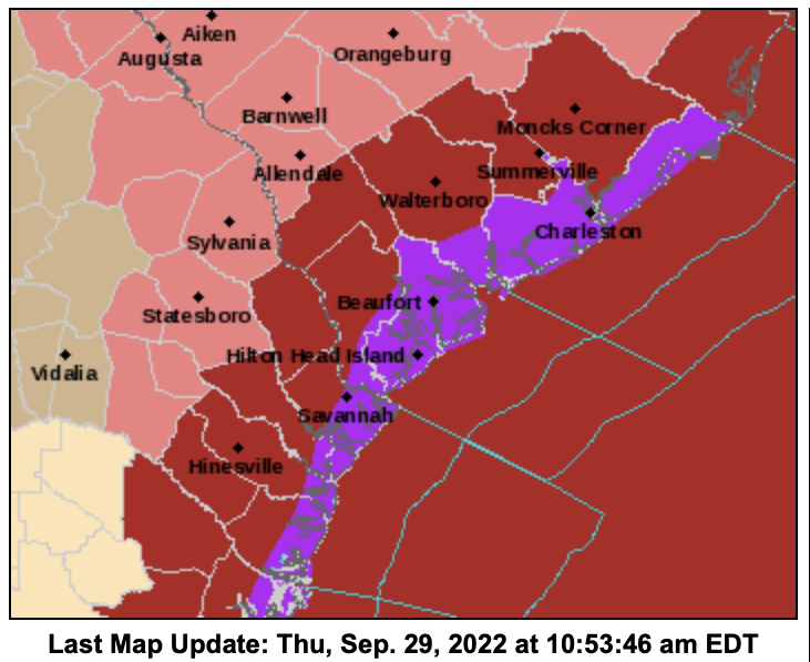
Much of Coastal Georgia — including Savannah's Chatham County — is under a tropical storm warning from the National Weather Service, putting residents on high alert for tropical storm-force winds (ranging between 36 and 73 mph) to arrive before Ian's center arrives.
Those winds are most likely to reach South Georgia on Thursday morning, according to the National Hurricane Center, making their way to Chatham later that night around 8 p.m.
- GPB's Benjamin Payne in Savannah
___
Wednesday, Sept. 28, 2022, 8 a.m.:
Governor Brian Kemp visits the State Operations Center at the Georgia Emergency Management and Homeland Security Agency (GEMA/HS) headquarters. Governor Kemp and GEMA/HS Director Chris Stallings will then answer a few media questions about Hurricane Ian and Georgia's preparations.
___
Wednesday, Sept. 28, 2022, 5 a.m.:
Steve Rowley, science and operations officer, with the National Weather Service, Charleston Office made a public statement: "I would just advise folks to keep up with the latest forecast because this is still in the future and there still may be some changes in the track and the intensity and so forth of the storm. And those changes will in turn alter the impacts."
___
Tuesday, Sept. 27, 2022, 3:54 p.m.:
Gov. Brian Kemp issues a state of emergency for all Georgia counties in preparation for Hurricane Ian's impact later in the week.
The State of Emergency will go into effect at 7:00am on Thursday, September 29. You can read the executive order 09.27.22.01 here.
Tuesday, Sept. 27, 3:45 p.m.:
Georgia Emergency Management and Homeland Security Agency provides tips on preparing for and dealing with flooding conditions:
Tuesday, Sept. 27, 2022, 11:16 a.m.:
The Associated Press Reported that the U.S. National Hurricane Center said “significant wind and storm surge impacts” were occurring Tuesday morning in western Cuba. Ian’s sustained top winds were 125 mph (205 kmh) and as much as 14 feet (4.3 meters) of storm surge was predicted along Cuba’s coast.
Ian was forecast to strengthen even more over warm Gulf of Mexico waters, reaching top winds of 140 mph (225 kmh) as it approaches the Florida’s southwest coast. Tropical storm-force winds were expected across the southern peninsula late Tuesday, reaching hurricane force Wednesday morning.
The current forecast for Coastal Georgia:
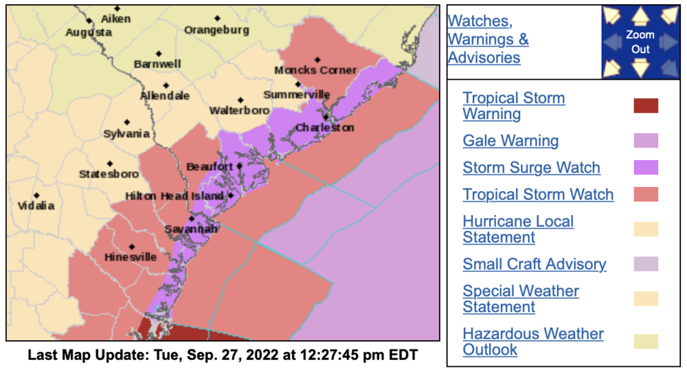
Click here to view the live storm map:
Secondary Content

Bottom Content
