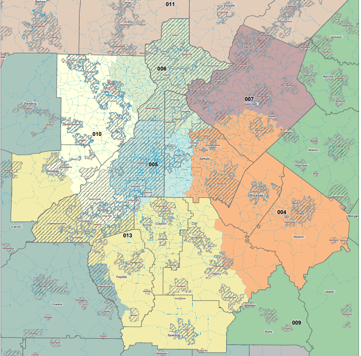
Caption
Georgia Democrats have released a proposed congressional redistricting map that splits 14 seats evenly between the parties.
Credit: Georgia Legislative and Congressional Reapportionment Office
There are practically infinite ways to redraw the boundaries for Georgia's state and congressional legislative districts, but only a few will be up for debate in the special session beginning Wednesday.
After the 2020 Census documented explosive population growth in metropolitan areas of the state and the 2020 election cemented a purple political shift, the General Assembly will be tasked with crafting new district lines that will last for the next decade.
There are now more than 10.7 million Georgians, a growth of more than a million new residents since 2010, driven by an influx of Black, Hispanic and Asian residents concentrated in Fulton, DeKalb, Gwinnett and Cobb counties. Those four counties accounted for nearly half of the state’s total growth. Other areas of growth that may see more representation include Forsyth County and areas surrounding Augusta and Savannah.
On the flip side, 67 counties lost population over the past decade, primarily in Southwest Georgia. At the state legislative level, the balance of power will continue to shift away from rural Georgia, as nearly 100 of the 180 state House districts are below the target population size of 59,511 people. That includes all but six districts south of Columbus, Macon and Augusta.
On the Senate side, only two districts south of metro Atlanta are not underpopulated.
With the new demographic and political reality, Republicans will likely draw state House and Senate maps that shrink their majorities, but keep the remaining seats safely in their control for the next 10 years. Republicans currently hold a 13-seat majority in the state House and a six-seat majority in the state Senate.
Here are all of the proposed maps by lawmakers and outside groups for the 2021 redistricting special session:
U.S. HOUSE
The target size for Georgia's 14 U.S. House districts is within one person of 765,136 people. Currently, eight Republicans and six Democrats represent the state.
Georgia Senate Republicans Map
Republicans in the Georgia Senate, led by Lt. Gov. Geoff Duncan, released a map Sept. 27 that would make the 6th Congressional District currently held by Democrat Lucy McBath into a conservative-leaning area while making Rep. Carolyn Bourdeaux's district fully within Gwinnett County and overwhelmingly Democratic. The map would likely turn Georgia's delegation to nine Republicans and five Democrats, but leaves several GOP-held seats in politically changing areas open to flipping later this decade.
Georgia Democrats Map
The Democratic Party of Georgia published its congressional map Oct. 21 that would move the 10th District from eastern Georgia to a Cobb County-based seat. One argument made along with the map is that it "rightly acknowledges that more than half of all Georgians live in metro Atlanta," so shifting another congressional district there would make sense. It would evenly split the congressional delegation 7-7 to mirror the state's almost 50-50 statewide vote in 2020, but is unlikely to pass the Republican-controlled legislature.
"Georgia Unity Map"
A coalition of nonpartisan advocacy groups including the Georgia NAACP and Georgia Coalition for the People's Agenda proposed a map Oct. 29 that would maximize nonwhite voting strength by drastically realigning the state's districts. The 7th District would run along I-85 from Peachtree Corners into Gainesville and include Alpharetta and south Forsyth County as a conservative-leaning district, move the 10th to Democrat-heavy Gwinnett, Rockdale and Newton counties and change the 12th District into a Democratic seat that includes Savannah and Augusta. This map would also evenly divide the delegation 7-7 and is also very unlikely to pass the legislature.
Georgia Republicans Joint Map
On Wednesday, Nov. 17 the House and Senate Republicans released a joint Congressional map that would redistribute voters in Atlanta's northern suburbs to create a safer Democratic seat in Gwinnett County's 7th district and an overwhelmingly conservative 6th district that puts Democratic Rep. Lucy McBath in a district that runs from Sandy Springs up to Dawson County. Southwest Georgia's 2nd district would dip slightly below majority-Black but keep its Democratic lean. With Republicans in both chambers backing the map, this is likely to become the new congressional map that would probably elect 9 Republicans and 5 Democrats.
GEORGIA STATE HOUSE
The target population for a state House district is 59,511 people, though there will be variation. Republicans currently hold 103 seats, Democrats hold 76 and one Democratic-leaning seat is vacant.
Georgia House Democrats Map
The Georgia House Democratic Caucus released its proposed map Oct. 29 that would shrink Republicans' majority by about five seats by targeting a tossup seat in Cobb County and creating new Democratic-leaning districts in Athens, Suwannee, Lovejoy and Buckhead. Republican-held seats in Walker, Dodge, Sumter and Athens-Clarke county would disappear, and an open GOP-leaning seat in Gwinnett County would move from Buford to Dacula and be nearly evenly split. This map would likely see 98 Republican districts and 82 Democratic districts based on 2020 election data. It also stands little chance of passing the GOP-led legislature.
"Georgia Unity Map"
A coalition of nonpartisan advocacy groups including the Georgia NAACP and Georgia Coalition for the People's Agenda released a proposed state House map Oct. 29 that would drastically overhaul the demographic and political power of the chamber to maximize nonwhite representation. More nonwhite and Democratic-leaning districts would be added in Southwest Georgia, Athens, eastern Georgia and the southern suburbs of Atlanta. The partisan breakdown of this map could see 101 Democrats and 79 Republicans, and is extremely unlikely to garner consideration in the special session.
The Georgia House Republican Caucus released its proposed map Nov. 2 that would sacrifice six seats of its majority to create safer districts that would last well into the decade. Six pairs of Republican incumbents would face off, though some are retiring, two sets of Democrats are paired together and two Republicans, southwest Georgia's Gerald Greene and Coweta County's Philip Singleton, would be drawn in with Democratic opponents in Democratic districts. New vacant House seats would be created in Forsyth, Cobb, Fulton, Gwinnett and Rockdale counties, and have a likely margin of 97 Republicans to 83 Democrats.
Georgia House Republicans Map, Version Two - PASSED
The Georgia House redistricting committee posted an updated proposal Nov. 8 before a committee hearing that makes changes to a handful of district boundaries but does not fundamentally affect the partisan balance. The map tweaks boundary lines in Forsyth, Cherokee, DeKalb, Gwinnett, Hall, Barrow and Fulton counties. The committee chairwoman Rep. Bonnie Rich (R-Suwanee) said some of the changes were to fix some districts that accidentally paired Democratic incumbents, left one out of his existing district and kept a Johns Creek-based seat fully within Fulton County. The map would have 97 likely Republican seats and 83 Democratic seats.
GEORGIA STATE SENATE
The target population for a state Senate district is 191,284 people, though there will be variation. Republicans currently hold 34 seats and Democrats hold 22.
Georgia Senate Democrats Map
Democrats in the Georgia Senate unveiled their proposal for the chamber Oct. 27 that would move a Republican district in South Georgia to a evenly split area of Gwinnett County and draw three GOP incumbents in McDonough, Athens and Roswell into Democratic-leaning seats. The map would likely keep Republicans in power, but with a three-vote majority: 31 seats to the Democrats' 25 out of the 56 total.
"Georgia Unity Map"
A coalition of nonpartisan advocacy groups including the Georgia NAACP and Georgia Coalition for the People's Agenda proposed a state Senate map Oct. 29 that would drastically overhaul the demographic and political power of the chamber to maximize nonwhite representation. Their map adds more Democratic districts in Southwest Georgia, Athens, suburban Savannah, Atlanta's southern suburbs and Atlanta's west side. The partisan breakdown of the map could be 30 Democrats and 26 Republicans and is also incredibly unlikely to see debate in the legislature.
Georgia Senate Republicans Map
Republicans in the Georgia Senate released their ideas for new lines Nov. 2 that would largely keep the status quo, creating a new Democrat district in fast-growing Gwinnett County by collapsing an underpopulated South Georgia district and moving another formerly-conservative seat from Bartow County into northern Fulton County. The Johns Creek-based seat held by Democrat Michelle Au is redrawn to be more conservative leaning, meaning these lines would have likely elected 33 Republicans and 23 Democrats.
Georgia Senate Republicans Map (SB 1EX) - PASSED
The Georgia Senate redistricting committee tweaked the original GOP-proposed map Nov. 4 with a map for the bill SB 1EX. Three Democratic districts traded some precincts around so districts 6, 33 and 38 look a little different. The primary shif centers arounds Dobbins Air Force base in Marietta. Currently in district 6, this proposal would move it and surrounding precincts to district 33, currently represented by Sen. Doc Rhett. This map still would have likely elected 33 Republicans and 23 Democrats.