Section Branding
Header Content
Tropical storm warning puts mid-Atlantic coast under threat of winds and flooding
Primary Content
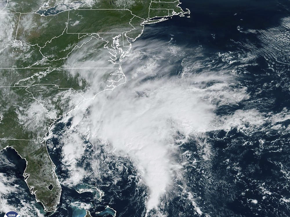
A disturbance in the Atlantic Ocean is expected to become a tropical storm as it nears the coast of North Carolina by Friday night and bring high winds, coastal flooding and life-threatening rip currents northward to New Jersey over the weekend.
The National Hurricane Center issused a tropical storm warning from Cape Fear, N.C., to Fenwick Island, Del., on Thursday, the center said. This includes Albemarle and Pamlico sounds in North Carolina, the Tidal Potomac River south of Cobb Island, Md., and Chesapeake Bay south of North Beach, Md. A storm surge watch was also in effect from just north of Wilmington, N.C., to the Potomac River in Virginia, just south of the Delaware line.
Between 3 to 5 inches of rainfall is expected across North Carolina and Virginia into Saturday, with as much as 7 inches falling in some areas. The Mid-Atlantic into southern New England, is forecast to get 2 to 4 inches of rainfall from late Friday into Sunday, which could create isolated urban and small stream flooding, forecasters said.
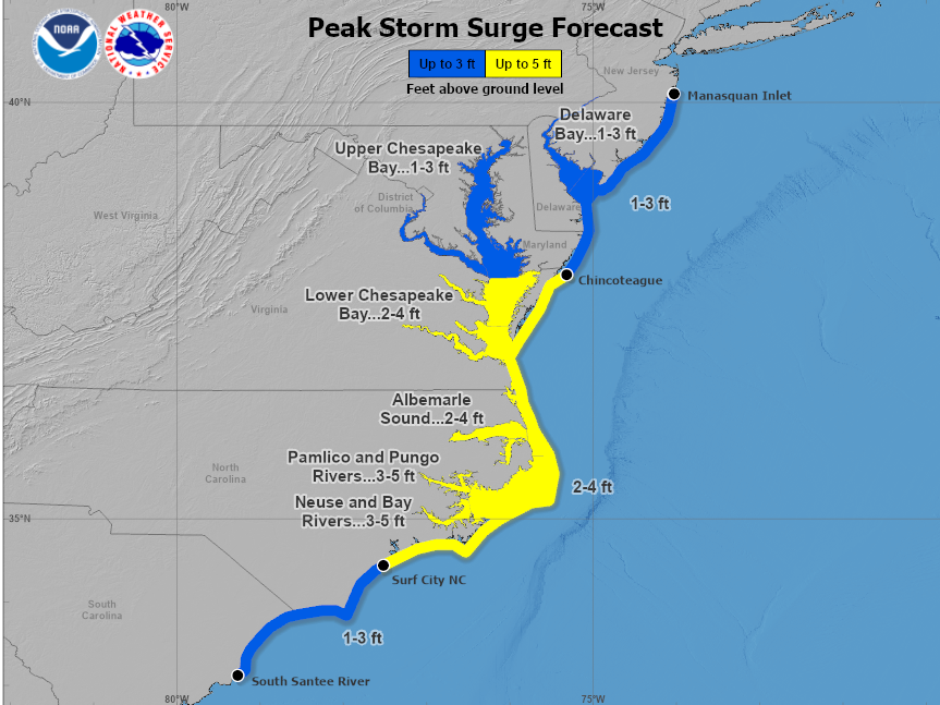
Areas stretching from Surf City N.C., to Chincoteague, Va., could see flooding of 2 to 4 feet if the storm surge peaks along with high tide, forecasters said. Portions of the Outer Banks are expected to see floodwaters rise between 3 and 5 feet.
The surge could cause flooding of 2 to 4 feet in the lower Chesapeake Bay and 1 to 3 feet father up the bay.
As it continues plotting a northerly path, the NHC said "the center of the cyclone is expected to approach the coast of North Carolina within the warning area Friday night and Saturday." "Potential Tropical Cyclone 16," as the NHC terms it, was moving to the north at 7 mph Thursday night and is expected to take a northwest-north path later Friday.
A few tornadoes are possible Friday and Saturday in the mid-Atlantic states, the NHC said.
Even if the system doesn't become a storm, the center said, dangerous tropical-storm conditions are likely in portions of the southeast and mid-Atlantic coasts. Forecasters don't expect the storm to turn into a hurricane.
If reaches tropical storm strength, it would be named Ophelia, the 16th named storm of the 2023 Atlantic hurricane season.
North Carolina Gov. Roy Cooper and the state's department of public safety urged residents across eastern and central portions of the state to be prepared for tropical weather over the next couple of days. Warning of the potential for downed trees, power outages and flooding, the officials also encouraged people to stay tuned to the latest weather forecasts.
"As tropical weather is threatening our state again, we are reminded of the importance of being prepared by having a family emergency plan and kit," Gov. Cooper said in a statement Thursday.
North Carolina Emergency Management director Will Ray said the department is prepared to provide needed resources.
Copyright 2023 NPR. To see more, visit https://www.npr.org.
Bottom Content
