Caption
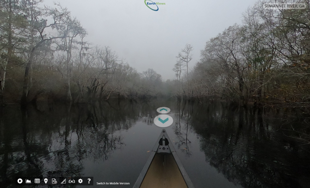
The Suwannee River in south Georgia is one of the rivers people can take a virtual tour of online as part of a Google “street view”-style mapping project.
Paddlers who have ventured out on South Chickamauga Creek as it winds through the far reaches of northwest Georgia will gush about the bluffs found along the water.
But you don’t need to take their word for it.
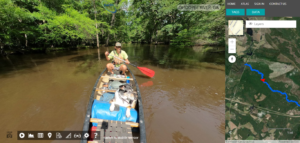
A new mapping project has volunteers like Joe Cook with the Georgia River Network out with a GoPro camera mounted to the front of his canoe snapping a photo every 10 seconds along waterways like South Chickamauga Creek and the Flint River. The public can follow along as Cook paddles under bridges and through rapids — often with his pup Oconee along for the ride.
Cook, who also writes river guidebooks, just spent about 10 hours a day on the Altamaha River for six days — taking thousands and thousands of photos that will be stitched together to offer a 360-degree digital map of the river on a site called EarthViews. Think Google “street view” but for rivers.
“I think most people, if you said South Chickamauga Creek, they’d be like, ‘Yeah, whatever,’” Cook said. “But if you go and do the (virtual) tour, you can see some of those bluffs and you’d say, ‘Oh, that looks like a pretty destination.’
“So, I think it’ll generate some interest in destinations around our state that maybe people haven’t thought of as far as paddling destinations,” he added. Cook pointed to the Ohoopee River, which starts in rural Washington County, as another example of an often-overlooked gem.
But the ambitions behind the project aim higher than providing recreational paddlers a handy way to scope out their next adventure.
“Google has mapped the planet of roads. We want to map the planet of waterways,” said Courtney Gallagher, a co-founder of EarthViews who lives in Texas.
“Not to be cheeky, but we do want to save the planet, by mapping the waterways in such a way that conservationists and scientists can actually use data and share data in a way that restores habitat, or protects habitat, and helps save those waterways.”
Gallagher said their platform can add layers that serve researchers, such as information about floodplains, invasive species or details about habitat, fish population and water quality. The mapping also creates a snapshot in time of how the rivers are currently faring, allowing for comparisons later for water levels and other changes.
The task is also daunting. The company wants mapping for any river someone is willing to paddle down and photograph for them. With about 3 million rivers in the country, there’s plenty of waterway to cover.
The company is mostly relying on volunteers to do the fieldwork. Gallagher says the company has about a dozen GoPros out right now, including one with Cook in Georgia. Another group here, the Suwannee Riverkeeper and WWALS watershed coalition, has photographed parts of the Withlacoochee River. Gallagher said she hopes to have all the state’s major water trails done in the next few years.
This additional resource is rolling out as many people are spending more time outdoors. Demand surged during the pandemic for outdoor recreational equipment like kayaks, making some items still hard to come by.
Cook said more people turning to the outdoors for recreation comes with its challenges, but as an environmentalist, he’s mostly thrilled about it.
“If you want to protect rivers, you need people to have a relationship with a river,” Cook said. “When they have a relationship with a river, they’re a lot more likely to take action to protect that river.
“So seeing people enjoying our rivers and having a great time on our rivers I think will translate into more awareness of the importance of protecting our rivers. But then you also have a double-edged sword in that the more people who are out on our rivers, the more impact they can have.”
There is also a greater chance for accidents, and last year brought an increase in the number of boating accidents and fatalities. Nationally, there were 767 boating fatalities, representing about a 25% increase from 2019, according to a recent U.S. Coast Guard report. Many of the deaths were caused by drowning.
Of the fatalities, 182 people died using a canoe, kayak, standup paddle board or inflatable craft. The majority of the deaths — 112 — involved a kayak.
Cook’s group is offering introductory kayaking classes to help newcomers stay safe on rivers and to encourage them to explore responsibly, such as packing up trash and staying off private property.
But he says the digital mapping can also help people prepare for what awaits them on the water, helping them discern whether they are ready for certain rivers.
“It’s a kind of try-before-you-buy type thing,” he said. “You can get on your computer and look at the river and go, ‘Oh, yeah, that seems like something I can do’ or ‘Oh, no, no, I don’t want to do that.”
This story comes to GPB through a reporting partnership with Georgia Recorder.