Section Branding
Header Content
Atlanta Gets Digitally Mapped During 'Mapathon'
Primary Content
Dozens of people hit the streets of Atlanta this weekend armed with GPS devices, to make the city the most digitally mapped in the country.
The online map is free... for the people by the people. It includes anything from bike trails to ATM’s to public art. Whatever point anyone wants to plug in they can.
About 150 volunteers did just that this weekend, trying to make a map of their city that’s more accurate than anything else on the market.
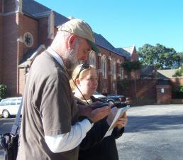
"If there’s a new trail or building or something cool in the city... as soon as somebody sees it, takes the GPS point and uploads the data, it’s there," says April Swank, a geography student at Kennesaw State University who just added some local churches. "You’re not looking at a map that’s two years old, which in Atlanta with our growth is a big deal."
The non-profit group Open Street Map heading up the project has already mapped much of Europe.
It says it focused on Atlanta to begin the US map because the city’s a hot spot for technological innovation and people here were so receptive to the idea.
Many Georgia Tech students mapped their campus this weekend.
View the map here.
Tags: Georgia Tech, open street maps, digital map, GPS
Bottom Content
