Section Branding
Header Content
Camp Mystic asked to remove buildings from government flood maps despite risk
Primary Content
The federal government allowed Camp Mystic, the all-girls summer camp along the Guadalupe River, to remove multiple buildings from government flood maps, even though private data suggests the flood threat remained, and was even worse than the government reported, according to documents and data NPR has reviewed.
The camp requested that FEMA, the agency responsible for creating maps that help warn Americans where water might rise, remove more than a dozen buildings from what FEMA designates a floodplain at least twice in 2013, 2019 and 2020, the documents show. That last request in 2020 coincided with a major expansion during which the camp built a number of new structures but does not appear to have taken down any cabins from dangerous flood areas.
The camp asked for the changes after FEMA created new maps in 2011 that placed much of the camp in a floodplain, an area the agency considers at high risk for flooding, according to records.
Removing structures from FEMA's flood maps can eliminate federal requirements to build in ways that can better withstand a flood, according to federal rules, usually by elevating buildings or shoring up foundations. It can also remove requirements for property owners to carry flood insurance.
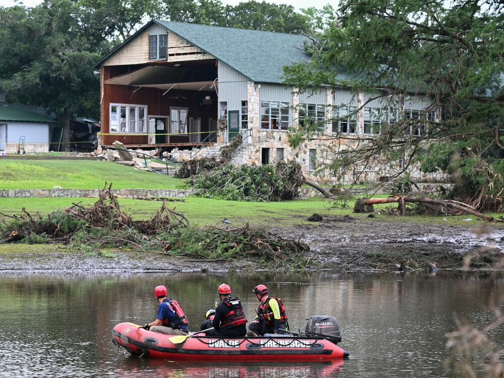
Many cabins and buildings at the camp were already at a higher risk of flooding than previously indicated by FEMA's maps, according to an analysis by NPR, PBS's FRONTLINE and data scientists. More than two dozen campers and counselors, along with the camp's owner, Dick Eastland, died in the flash floods that swept the camp on July 4.
First Street, a climate risk modeling company in New York City which makes maps, show at least 17 structures in the path of flood waters, compared to FEMA's current maps at the camp. It's unclear from FEMA's records which specific buildings the camp appealed to have removed from the map.
Camp Mystic did not respond to requests for comment on the removals, which was first reported by the Associated Press. FEMA said in a statement that its maps should not be compared to those created by private companies, as the agency has to undergo public review when it updates its maps.
The biggest difference between FEMA's maps and those created by the private sector, is that FEMA does not map rainfall or flash flooding, according to Jeremy Porter, a data scientist at First Street. Instead, FEMA relies on data from coastal storm surges and large river flooding, even as climate change has made extreme rainfall events more common.
The problem isn't limited to Kerr County, Texas, but exists nationwide, according to Porter. The group found that twice as many Americans live in dangerous flood-prone areas as FEMA's maps suggest, and many may not even realize they are at risk.
Even when FEMA's maps serve as a warning, they are sometimes ignored, according to an investigation by NPR and PBS. At least four of the camp's cabins that housed younger campers — as well as the camp's recreation and dining halls — were located within what FEMA calls a floodway. It's an area FEMA describes as the most hazardous flood zone that is expected to see the highest velocity and highest depth of water during a flood.
Bottom Content
