Section Branding
Header Content
The U.S. has special rules for satellites over one country: Israel
Primary Content
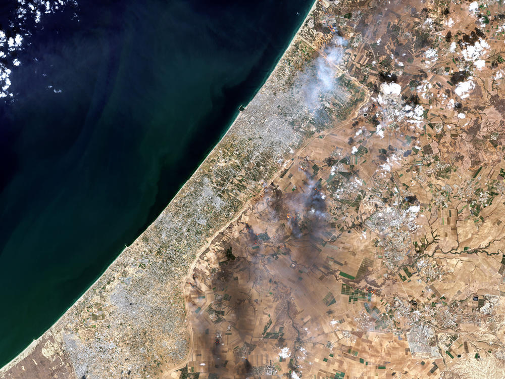
The war between Israel and Hamas is being fought, in part, through disinformation and competing claims — and satellite imagery has emerged as an important fact-checking tool. It's also putting new scrutiny on how commercial satellite companies operate in a conflict area.
The questions are more pointed than ever. Not only are companies able to capture crystal-clear overviews of things like military convoys and battlefield positions; they're also able to deliver those images more quickly and widely than ever.
By publishing — or not publishing — real-time imagery, private satellite firms face a risk of serving the interests of combatants on either side, in a controversial war.
If that's not complicated enough, consider this: The U.S. government has a special law restricting satellite imagery that depicts Israel.
Here's an overview of that law, and how satellite companies are navigating a hotly contested conflict zone:
How long has the U.S. restricted satellite imagery of Israel?
It's a unique situation: For years, federal law has limited the quality of commercial satellite imagery U.S. companies can sell — if the images depict Israel and Israeli-occupied Palestinian territories such as Gaza.
It's not unusual for countries to attempt to restrict satellite imagery of sensitive locations on their own soil. But in this case, the law seeks to protect an entire — and separate — country.
"This restriction doesn't even apply to the U.S." homeland and territories, satellite imagery analyst Matt Korda of the Federation of American Scientists told NPR.
The limit has its roots in 1996, when Congress added an amendment on satellite imagery to the National Defense Authorization Act for the following fiscal year.
Under the Kyl-Bingaman Amendment, or KBA, the office of Commercial Remote Sensing Regulatory Affairs, which is part of NOAA, can issue a U.S. license for collecting or distributing satellite images of Israel "only if such imagery is no more detailed or precise than satellite imagery of Israel that is available from commercial sources" — meaning outlets beyond the U.S.
For more than two decades, the resolution limit was set at 2 meters. So as technology and access to orbit improved, U.S. satellite companies lagged behind competitors such as the EU-based Airbus in providing images of Israel. Things finally changed three years ago, when the U.S. acknowledged that, with at least a dozen companies in eight countries offering imagery far superior to 2-meter resolution, the commercial satellite sector had surpassed the U.S.'s ability to control it.
So in 2020, the CRSRA sharply lowered the KBA's allowed resolution, from 2 meters to .40 meters — meaning one pixel in a satellite image of Israel can now depict a square on the ground measuring 40 centimeters by 40 centimeters. For reference, that's around the width of the handlebars on a 10-speed bicycle.
"That's certainly enough to be able to make out what is going on on the ground at a pretty high fidelity," Korda said.
Israeli officials were unhappy with the change.
"We would always prefer to be photographed at the lowest resolution possible," said retired Brig. Gen. Amnon Harari, head of Israel's space programs, at the time. "It's always preferable to be seen blurred, rather than precisely."
The change was a boon for researchers like Korda, who studies nuclear programs in Israel and elsewhere. While some satellite companies can collect data at higher resolutions than .40 meters, the new limit narrowed what used to be a wide gap in quality.
"There isn't a huge difference at this point anymore between what's available for looking at the United States and looking at Israel," he said. But, he added, the situation will eventually shift again, as resolution on international images continues to improve.
"That being said, the fact that the KBA even exists is clear indication that Israel is treated differently than other countries" by the U.S., Korda added.
Are Israel and Gaza being treated differently since Oct. 7?
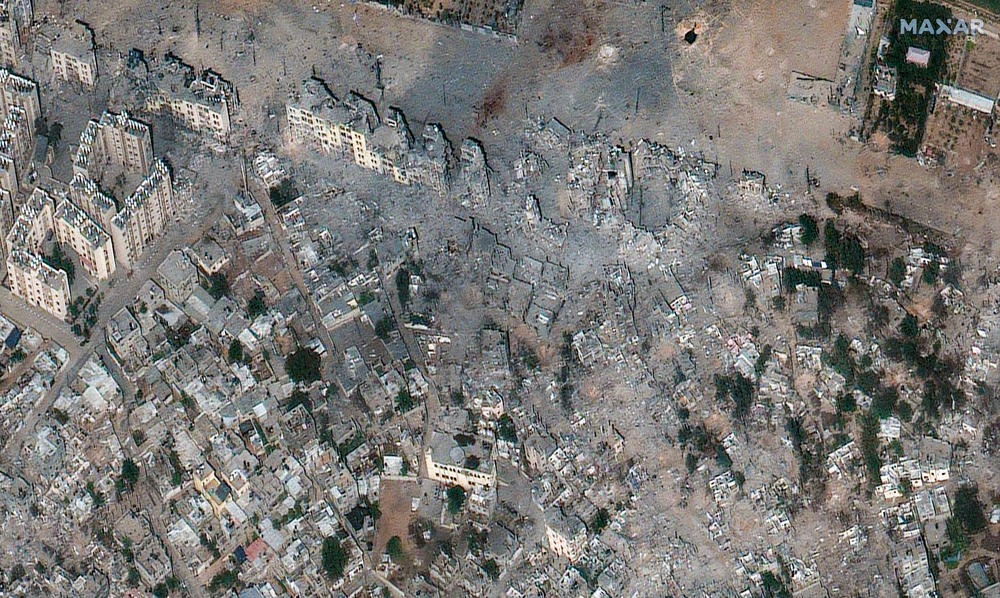
"To me, the availability of high-resolution satellite imagery over Gaza is practically the same as it was before the war," said Jeffrey Lewis of the Middlebury Institute of International Studies at Monterey, who regularly studies satellite data.
There have sometimes been gaps in images depicting the war, Lewis said, but he added that the reasons could be mundane, such as technical complications or a big satellite customer, such as the U.S. military, buying an image outright — something it has done before and after the war began.
But there has been at least one change in how Planet Labs, a prominent U.S. company, distributes Gaza images, Lewis added.
"The only difference is Planet had a really unusual arrangement where if I tasked a satellite, that image pretty much goes in the catalog as soon as they take it and everybody gets to see it," Lewis said. "Instead, what they started doing was distributing high-resolution images of Gaza through a folder so that media could access it, but so that combatants could not."
When asked how Planet handles distributing images of a war zone, a company spokesperson sent a statement sent to NPR saying, "To reduce the potential for misuse and abuse, we decided to apply additional review for SkySat imagery over the conflict region."
Planet says it's continuing to make images of Gaza available to media and humanitarian organizations and other clients, noting that it has shared detailed images that were then featured in news stories detailing the war's impact.
NPR also sought comment from Maxar Technologies, another leading U.S. satellite firm, but those messages were not returned before this story was published.
Accusations have arisen that satellite companies like Planet might be redacting images of Gaza. When asked for a response, the Planet spokesperson said the company "does not censor, modify, obscure, or manipulate images."
Korda, of the FAS, says he hasn't seen any manipulations of images regarding the current conflict. And in general, he said, the precautions taken by companies like Planet strike him as responsible moves.
But if Hamas wants to see accurate satellite imagery, it has options — including imaging satellites launched by Iran.
"Governments and terrorist groups alike want all the data they can get," Lewis said. "So I'm sure Hamas wants this kind of data, just as I'm sure the United States and Israeli military want this kind of data."
So, who buys satellite images?
Detailed satellite images were once the province of secretive government agencies. But high-fidelity satellite photos are now a regular part of the news diet for millions of people, bringing before-and-after views of everything from natural disasters to genocidal violence from around the world.
And in many cases, governments and defense agencies are private satellite companies' biggest customers.
Last month, Planet told its investors that two sectors — "defense and intelligence" and "civil government" — were the company's two most lucrative areas for million-dollar-plus sales of annual contracts. And Lewis notes that for Maxar, the federal government is the company's biggest client.
"It is normally the case that in a conflict situation, we tend to see fewer Maxar images because they because the U.S. government is simply buying them," Lewis said. "But that's not a change, that's not a restriction. That's just a particular quirk of that company's business model."
Asked whether, for instance, the Israel Defense Forces might attempt to buy up images of their own positions, so no one else would have access to them, Lewis replied, "If I were the IDF, I would try to do that."
But, he added, "there are now so many companies and those companies are based around the world that buying up every image is going to be pretty tough."
Satellite companies also serve a wide range of smaller customers, from nongovernmental and aid organizations to media and think tanks. They each follow their own pricing models, with costs depending on factors such as whether the user wants to view or download the imagery, or publish it.
"Anybody who actually has worked with the satellite imagery industry knows getting a price can be the hardest part of any negotiation," Lewis said. Often, he said, "the cost of access can range from a few thousand dollars upward from there."
The companies also have differing levels of capabilities.
"Planet is a company that, their whole ethos is wanting to image the entire globe basically every day. Which is incredible, right?" Korda said. "That is an amazing achievement. But it's a really different type of model than a company like Maxar, which has extremely powerful satellites, but they don't image as often."
Korda says it's healthy for the public to think about where satellite images come from, and who's providing them, as he's seen an increase in countries openly manipulating satellite imagery data.
"I think that's kind of the direction that we're heading," he said, "just based on how countries are already trying to sometimes censor and manipulate data when sharing it with researchers."
And of course, if an interested party wants to obtain an image that doesn't comply with limits set by U.S. laws or companies, other options are out there, including from Chinese outlets.
"We have found that you can almost always get a picture of any place," Lewis said. "It's just a matter of finding the provider who has the capacity to take that picture."
Copyright 2023 NPR. To see more, visit https://www.npr.org.
Bottom Content
